|
|
Location: South Front Range > Arkansas
Valley
W End: 1920s-1948: Jct SH 55 at Branson;
1949-1968: Jct US 350 at Beshoar Junction northeast of
Trinidad
E End: 1920s-1938: Jct SH 51 at Walsh;
1939-1968: Kansas border east of Walsh
History:
SH 100 is the original 1920s state highway number
for current US 160 in the southeast part of the state.
Originally, US 160 used SH 55 east from Trinidad via
Trinchera to Branson. SH 100 then started at Branson
and went north, then east via Pritchett and Springfield to
Walsh, ending at SH 51. Originally, US 160 used SH
116 to go east into Kansas. By 1939 SH 100 had been
extended east so that it did hit the Kansas border. By 1949
the SH 55 routing of US 160 was being abandoned so
SH 100 was extended from Branson west to Beshoar
Junction, and it was paved from Springfield to Walsh. By
1955 it was paved from Beshoar Junction east for 15mi and
from Pritchett to Kansas. By 1958 the only section not paved
was from SH 389 to Kim, and that was paved by 1963.
The spur south into Vilas (current SH 100, see below) was
added about 1965. SH 100 was the carrier route for US
160, so it was decommissioned along with the other carrier
routes in the purge of 1968.
|
|

|
Location: Vilas (Southeastern Arkansas Valley)
Length*: 0.41mi
N End: Jct US 160 north of Vilas
S End: A & Main Streets in Vilas
Counties: Baca
Annual Average Daily Traffic (2008): 400
Guide:
A short spur. It starts at US 160, and heads due south
to Vilas, population 110.
History:
What is now SH 100 became a state highway about 1965. It
was numbered as a spur off of SH 100 (see above) that
was the number for US 160 across southeast Colorado. During
the 1940s, there was another highway in the same area
numbered SH 197, but that route went a good 20mi
south of Vilas.
|
|
|
|
|

|
Location: Arkansas Valley
Length*: 21.41mi
N End: Jct US 50 at Carson Ave./7th St. in Las
Animas
S End: CRs K & 18 at Toonerville
Counties: Bent
Places: Las Animas, Toonerville
Annual Average Daily Traffic (2008):
- 2200 at US 50, Las Animas
- 2500 south of 9th Street
- 270 south of CR BB
- 70 at Toonerville
Guide:
SH 101 starts in central Las Animas, then heads south
via Carson Ave., then southeast out of town. It generally
follows a BNSF rail line which goes from Las Animas to
Springfield. Toonerville
appears to be nothing more than a
rail siding.
History:
SH 101 is an original 1920s state highway. At first, it
went from Las Animas south to US 160 at Pritchett. By 1939,
it was extended south, stopping just short of the Oklahoma
border. By 1954, the southern section of it had been turned
back so that it went south only to Toonerville as now. Paved
by 1968.
|
|
|
Location: Eastern Plains
W End: 1920s-1954: Jct US 40-287 at Strasburg;
1955-1968: Jct US 40-287 at Byers
E End: Kansas border east of Idalia
Via: Byers, Last Chance, Cope, Idalia (current US 36)
History:
SH 102 is the original 1920s number for US 36 on the
Eastern Plains. It started at Strasburg, and then went east
to Kansas. In 1955 things had been shifted around, and US
36/SH 102 veered southwest to Byers instead of going
west to Strasburg. US 36 was extended into Colorado in 1930,
and so from that point on SH 102 was the de facto
carrier route for it. It was decommissioned along with the
other carrier routes in the purge of 1968.
|
|

|
Location: Central Mountains
Length*: 22.48mi
NW End: Jct BL I-70 at 13th Ave./Colorado Blvd. in
Idaho Springs
SE End: CRs 151 and 103 at Squaw Pass
Counties: Clear Creek
Places: Idaho Springs, Echo Lake, Squaw Pass
Roadways Names: From Idaho Springs to SH 5, part
of the Mount Evans Highway.
 Scenic & Historic Byways: Mount Evans Scenic & Historic Byways: Mount Evans
Milepost Guide:
- 0.00: BL I-70, Idaho Springs (begin SH 103 in Clear Creek County)
- 0.11: I-70 Exit 240 interchange at Idaho
Springs
- 13.26: SH 5, Echo Lake
- 22.48: CR 151, Squaw Pass (end SH 103)
Annual Average Daily Traffic (2008):
- 5300 north of I-70
- 2000 south of I-70
- 580 northwest of SH 5
- 260 at Squaw Pass
Guide:
After
starting in central Idaho Springs, SH 103 heads south on 13th Ave.
through I-70 Exit 140, then goes southwest on a leisurely alignment via
Chicago Creek. SH 103 then has numerous switch backs as it starts
climbing. At Echo Lake, SH 103 meets SH 5 at an elevation of 10,600 ft,
where one can go up SH 5 to the top of Mount Evans. From Echo Lake, SH
103 heads east on a rolling mountain alignment. Squaw Pass is not a
noticeable topographical feature as one is driving along. SH 103 ends
at the CR 151/Little Bear Creek Rd intersection and becomes CR 103, which continues east to SH 74 at Bergen Park.
Photo Gallery:
- Echo Lake. Looking north on SH 103 as it passes along side Echo Lake. (August 2004)
History:
SH 103 is an original 1920s highway. It
started in Idaho Springs and headed south to Echo Lake, then south to
the south side of Mount Evans. Maps before 1927 then show it going
southeast to SH 8 (current US 285) north of Bailey (Deer Creek
Junction). After 1927 SH 103 is shown from Mount Evans going southwest
via Scott Gomer Creek to Grant. It's unlikely that either of the two
routes south of Mount Evans ever actually existed, or if they did were
extremely primitive. Starting with the 1930 map the section along Scott
Gomer Creek is noted as "unimproved" or "impassible".
The section of the road up to the summit of Mount Evans, with
all the switchbacks on the south side of the mountain, was completed in
1927.
By 1939 SH 103 was paved from Summit Lake to Idaho Springs.
The projected section along Scott Gomer Creek was dropped from maps in
1952. In 1954 the road up Mount Evans was taken off the state highway
system, and from Echo Lake SH 103 was run east to Squaw Pass along what
had previously been SH 68. The Mount Evans road was returned to the state highway system in 1955 as SH 5.
|
|
|
Location: Western Mountains
Length: 57mi
W End: Jct SH 82 at Basalt
E End: Jct US 24 at Leadville
Places: Basalt, Meredith, Carlton Tunnel, Leadville
History:
SH 104 is an original 1920s highway, and went from SH 82 at
Basalt, east via the Fryingpan River to Meredith, through
the Carlton Tunnel (toll), to US 24 at Leadville. There was
a tunnel collapse in 1943, and SH 104 was
decommissioned by 1950.
Here's a history of the Carlton Tunnel from Ben Kiene,
from the book The Passes of Colorado by Ed and Gloria
Helmuth:
The abandoned Carlton Tunnel under Hagerman
Pass near Leadville is used as a water diversion tunnel
today to bring water from the wet Western Slope of the
Continental Divide to the dryer and more populated
Eastern Slope. It is one of three tunnels built to cross
this pass. The first two, the Hagerman and Busk-Ivanhoe
Tunnels, were used by the Colorado Midland Railroad. The
CDH (now CDOT) rebuilt the Hagerman Tunnel and renamed it
as the Carlton Tunnel in the 1920's and SH 104 used it
until 1943, when a portion of the tunnel collapsed. The
Boustead tunnel is a much larger and newer water
diversion tunnel that runs below the other two. The
current road over the pass is a rough 4WD route not
maintained by the state.
The Carlton Tunnel now moves water between Ivanhoe Lake
and Busk Creek.
|
|

|
Location: South Front Range > South Metro
Denver
Length*: 8.81mi
Counties: El Paso, Douglas
Places: Monument, Palmer Lake, Sedalia
Broken Route: Several sections of SH 105 have been turned back, leaving two disjointed sections of it.
- South Section
Length*: 4.34mi
Southeast End: Woodmoor Drive, within the I-25 Exit 161 interchange
Northwest End: El Paso-Douglas County line in north Palmer Lake
Milepost Guide:
- 5.14: Woodmoor Drive (begin SH 105 in El Paso County)
- 5.21: I-25 Exit 161 interchange, Monument
- 9.48: El Paso-Douglas County line, Palmer Lake (end
SH 105)
- North Section
Length*: 4.47mi
South End: Perry Park Road/Wolfensberger Road west of Castle Rock
North End: Jct SH 67 just south of Sedalia
Milepost Guide:
- 28.16: Wolfensberger Road west of Castle Rock
(begin SH 105 in Douglas County)
- 32.63: SH 67, Sedalia (end SH 105)
Annual Average Daily Traffic (2008):
- 12,500 east of I-25
- 19,600 west of I-25
- 7200 north of Peakview Blvd., Monument
- 3400 north of Glenway Ave., Palmer Lake
- 1100 at El Paso-Douglas County Line
- 2200 south of SH 67
Memorial Designations:
Medal of Honor Master Sargent William J Crawford Highway, from County
Line Road in Palmer Lake to Beacon Lite Road in Monument. Crawford won
of the Medal of Honor for conduct in Italy in WWII and lived in the
Monument area until passing away in 2000.
Guide:
As you can see, because a section in the middle has been
turned back, SH 105 has two distinct sections. The one in
the south starts at the Woodmoor Drive intersection, just east of I-25, and then heads west. It goes
through I-25 Exit 161 at Monument, a congested interchange.
On the west side of the interchange in Monument, SH 105
takes an abrupt right turn to the north, heads through
Monument's strip, then drifts northwest to Palmer Lake. On
the north edge of Palmer Lake it begins heading north on
Spruce Mountain Road, but then turns left onto Perry Park
Road then ends at the El Paso-Douglas County Line a short
distance later. The south section of SH 105 is 4.77mi long.
The north section of SH 105 is short, only 4.34mi long. It
starts that distance south of SH 67 (at the intersection
with Wolfensberger Rd.), then heads north on Perry Park Rd to SH 67 just
south of Sedalia.
Photo Gallery:
History:
SH 105 is an original 1920s highway. It started at old
US 85-87 (Spruce Mountain Rd) at Palmer Lake, and went north via Perry Park Road
to Sedalia. Section east of I-25 was at first SH
50. By 1954, US 85-87 had been moved to
I-25's current alignment, so SH 105 started at Monument, and
went north for 10mi via Palmer Lake; there was also the spur
south from Sedalia as now. The south section was trimmed
back to I-25 to Palmer Lake only by 1963, and SH 105 was
entirely paved. SH 105 was extended east along SH
50's
routing to SH 83 in the purge of 1968 to eliminate duplication with US
50. The section between SH 83 and I-25 was turned back
October 1, 2007, although it took several months for signage to change.
|
|
|
Location: South Western Slope
Length: 27mi
S End: New Mexico border south of Cortez
N End: Jct US 160 in Cortez
History:
SH 106 is the original 1920s number for current
US 491 from Cortez south to New Mexico. Since it was a
carrier route, it was eliminated with the other carrier
routes in the purge of 1968.
|
|
|
Location: Western Mountains
SW End: Jct SH 82 north of Carbondale
NE End: Jct US 6 at Gypsum
History:
Original 1920s state highway which went from SH 82
between Cardiff and Carbondale northeast to US 6 at Gypsum.
Eliminated by 1954.
|
|
|
|
|
|
Location: South Western Slope
W End: Jct SH 145 west of Telluride
E End: Telluride
History:
Original 1920s number for the old SH
145 spur east to Telluride. It was renumbered as a spur
of SH 145 about 1954.
|
|

|
Location: Arkansas Valley
Length*: 65.33mi
S End: Jct US 160 north of Kim
N End: Grand Ave./4th St. in Cheraw
Counties: Las Animas, Bent, Otero
Places: Kim, La Junta, Cheraw
Spur Connection:
From US 50 at Bradish Ave. in La Junta southeast via Bradish
and 3rd St. to SH 109
|
Milepost Guide:
- 0.00: US 160 (begin SH 109 in Las Animas County)
- 27.53: Enter Bent County
- 30.99: Enter Otero County
- 56.01: Spur SH 109/3rd St., La Junta
- 57.43: SH 194, North La Junta
- 63.25: SH 266 north of La Junta
- 65.33: 4th St., Cheraw (end SH 109)
|
Annual Average Daily Traffic (2008):
- 230 at US 160
- 380 north of CR 54
- 1400 north of 22nd Street, La Junta
- 5100 north of 3rd St/Spur 194
- 2500 north of SH 194, North La Junta
- 870 north of SH 266
- 620 at Cheraw
|
Guide:
This one goes through some sparse country. After
starting at US 160 north of Kim, it spends 56 lonely
miles going north to La Junta. There is one locale passed
through, a place called Higbee west of the Bent-Otero County
Line, and north of the Purgatoire River bridge.
In La Junta, SH 109 comes into town on Adams Avenue. It
heads north on Adams and at 3rd Street goes up and over a
long, curving viaduct bridge that takes it over US 50, railroad tracks and the
Arkansas River. Since the bridge takes it over US 50 a
spur connection is needed connecting US 50 and SH 109. After
going over the Arkansas River, SH 109 goes into North La
Junta. It's labeled as Main St. through that town. Going
north it passes by the west side of La Junta Municipal
Airport, continues north, then at Otero CR JJ.5 abruptly
turns east toward Cheraw. It goes one short mile and into
town on Grand Ave., ending at 4th St.
Photo Gallery:
History:
SH 109 is an original 1920s state highway, and at first
went from Karvel east and north through Hugo to Genoa. By
1939 several new sections had been added: Spurs north and
south from US 160 at Kim, from La Junta south to the
Purgatoire River, from La Junta north to Cheraw, and from
Karval south to SH 96 at Lolita. By 1946 it was paved from
Hugo to Genoa, and from La Junta to Cheraw by 1950.
By 1954 a lot of SH 109 had been turned back, so it went
only from La Junta north to Cheraw. The spur from La Junta
southeast for 19mi to the Purgatoire River had been brought
back by 1964, and everything was paved by 1965. It was
slowly extended south toward Kim: 10mi into Las Animas
County by 1974; to about 12mi short of US 160 by 1978;
finally to US 160 by 1983.
  Lincoln
County retained the "CO HWY 109" designation for a lot of the historic
SH 109 alignment, such as between Genoa and Hugo (picture at right).
South of Hugo, the road is sporadically co-marked at intersections with
two sign blades, one with the CO HWY 109 name and another with the name
it would normally be based on the county grid (Rd 31 or Rd 32). The
co-marking continues south of Karval along CR 32 to about CR F, even
though historically it was CR 27 that SH 109 went south along to SH 96
along, not CR 32. Additionally, there are Lincoln County 109 markers on
US 40-287 in Hugo (picture at left) and on SH 94 at the CR 32
intersection. Thanks to Dale Sanderson for some of this info. Lincoln
County retained the "CO HWY 109" designation for a lot of the historic
SH 109 alignment, such as between Genoa and Hugo (picture at right).
South of Hugo, the road is sporadically co-marked at intersections with
two sign blades, one with the CO HWY 109 name and another with the name
it would normally be based on the county grid (Rd 31 or Rd 32). The
co-marking continues south of Karval along CR 32 to about CR F, even
though historically it was CR 27 that SH 109 went south along to SH 96
along, not CR 32. Additionally, there are Lincoln County 109 markers on
US 40-287 in Hugo (picture at left) and on SH 94 at the CR 32
intersection. Thanks to Dale Sanderson for some of this info.
Here's a history of SH 109 in La Junta from Dan Chrisner:
Originally US 50 went through town on 3rd Street. SH 109
started at 3rd and Bradish Avenue and went north from there,
under a 10-foot clearance railroad underpass, over a
concrete arch bridge built around 1921 over the Arkansas
River and north on to Cheraw. Southbound SH 109 went from
3rd & Colorado Avenue south to 10th Street, west on 10th
to San Juan Avenue, south on San Juan past Otero Junior
College and out of town to Kim.
US 50 was moved from 3rd to 1st Street in 1963, but SH
109 continued using the same cross streets, Bradish and
Colorado, intersecting it. In late spring 1967 a new bridge
for SH 109 over the railroad and river opened, and SH 109
came east on 2nd Street to Bradish then north to US 50 (1st
Street). The 10-foot underpass was filled in and the 1921
bridge dismantled.
When SH 109 was paved south to Kim in the early 1980s
trucks started using it to avoid the port of entry at Lamar.
Trucks were rumbling through town on San Juan and 10th,
streets not meant for semis. So, in the late 1980s or early
1990s SH 109 was rerouted south of US 50 so that from the
bridge at US 50 it continued south on Adams Avenue out of
town then swung west on a new alignment to meet the original
road. This was a three-way project: The City of La Lunta
handled the portion inside city limits, Otero County did
design for the portion outside city limits and CDOT did the
paving outside the city limits.
Thanks Dan!
|
|

|
Location: Silverton (Southwestern Mountains)
Length*: 0.14mi
SW End: Jct US 550 in Silverton
NE End: Maintenance yard entrance road
Counties: San Juan
Average Annual Daily Traffic (2008): 2400
Notes:
While
0.14mi of SH 110 is still shown in CDOT's log of state highways, CDOT
no longer considers it a real part of the state highway system. The 740
feet was retained as CDOT property to keep access from US 550 to the
Silverton maintenance yard. No signs for SH 110 appear in the field.
The intersection at US 550 refers to it as CR 2 and CR 110.
History:
SH 110 is an original 1920s highway, going from US 550
northeast up Greene Street through Silverton to Howardsville. By 1938 it had been extended
northeast to Eureka. By 1961 SH 110 was totally rerouted so
that it went from Silverton north *7.71mi along Cement
Creek, ending at Gladstone. By 1963 a Spur
SH 110 was added which went from SH 110 on the north
side of town east *1.95mi to Mayflower Mill, a mining
structure.
In mid 2003 nearly all of SH 110 was turned back (including
the spur route) to Silverton and San Juan County. CDOT retained 740
feet from US 550 to its Silverton maintenance yard, but all vestiges of
SH 110 disappeared from the field. All sections of it became CR 110.
The section north to Gladstone was never paved.
|
|
|
Location: South Mountains
History:
SH 111 is an original 1920s state highway, going
from the New Mexico border north via Stonewall and Cuchara
to La Veta. By 1939 it was extended north to SH 69. By 1954
it had been significantly turned back, so that it went from
US 160 south to Cuchara only. That section was paved by
1963. SH 111 was then extended south over gravel to
SH 12 at Monument Lake by 1964. Starting from then, SH 12
and SH 111 ended at each other at Monument Lake.
SH 111 was then renumbered as an extension of SH 12
about 1968.
|
|

|
Location: San Luis Valley
Length*: 27.80mi
W End: Jct US 160 at Oak St./Grand Ave. in Del
Norte
E End: Jct SH 17 at Hooper
Counties: Rio Grande, Saguache, Alamosa
Places: Del Norte, Center, Hooper
Milepost Guide:
- 0.00: US 160, Del Norte (begin SH 112 in Rio Grande County)
- 7.43: Begin Rio Grande/Saguache County split
- 13.13: US 285 west of Center
- 19.32: Begin Alamosa/Saguache County split
- 27.80: SH 17, Hooper (end SH 112)
Annual Average Daily Traffic (2008):
- 2600 at US 160, Del Norte
- 1600 west of US 285
- 1700 east of US 285
- 4600 at Broadway St., Center
- 540 at SH 17
Guide:
SH
112 starts in central Del Norte, and heads north out of town on Oak St.
It crosses over the Rio Grande, then curves northeast. It then
heads east and travels along the Rio Grande-Saguache County line. 13mi
from Del Norte, it hits US 285. The section from Del Norte to US 285
serves as a regional shortcut for traffic going from central to
southwestern Colorado, say from Denver to Durango. Just east of
US 285, SH 112 goes through Center, skirting the south side of town
along 8th St. SH 112 then continues arrow-straight eastward, finally
ending at SH 17 on the north side of Hooper.
Photo Gallery:
- End at US 160.
A shot of the signs on westbound SH 112 approaching US 160 at Oak
St/Grand Ave in Del Norte. Photo by Dale Sanderson. (May 2008)
History:
SH 112 is an original 1920s state highway. No major
alignment changes. Paved from Del Norte to US 285 by 1949,
to Center by 1950, and entirely by 1954.
|
|
|
|
|

|
Location: North Eastern Plains
Length*: 18.83mi
S End: Jct US 138 northeast of Sterling
N End: Nebraska border north of Peetz, connecting
with NE
19 (link to Chris Geelhart's site)
Counties: Logan
Places: Peetz
Annual Average Daily Traffic (2008):
- 1200 at US 138
- 1400 noth of CR 72
- 1500 at Nebraska border
Guide:
SH
113 starts at US 138 between Sterling and Iliff, and then heads due
north across the rolling plains. At Peetz, it curves northeast and
follows a BNSF rail line to the Nebraska border. For an Eastern Plains
highway SH 113 is fairly well-traveled, and maps that differentiate
between primay and secondary highways usually show SH 113 as primary.
In fact, back when the old FAP/FAS system was still around, it was
Federal Aid Primary. Looking at it at first, it would be hard to figure
out what makes SH 113 so important, but if you go into Nebraska to
Sidney, you can see that is where US 385 heads north from I-80. SH 113
serves as the cut-through for traffic going from northeast Colorado to
Sidney and points north via US 385.
Photo Gallery:
- South Platte Valley. Southbound on SH 113 as it makes its final descent into the South Platte Valley approaching US 138. May 2007
- South of Peetz. Southbond SH 113 as it loses elevation coming down from the "Peetz Table" south of town. May 2007
- Peetz. The grain elevator is visible as southbound SH 113 goes through Peetz. May 2007
- Nebraska Border.
Southbound SH 113 as it changes from N-19 at the Nebraska border. This
crossing features a smaller version of the state welcome sign. May 2007
History:
SH 113 is an original 1920s state highway. Paved by
1939.
|
|
|
|
|

|
Location: Central Mountains > San Luis
Valley
Length*: 61.69mi
NW End: Jct US 50 northwest of Parlin
SE End: Jct US 285 at Gunnison Ave./8th St. in
Saguache
Counties: Gunnison, Saguache
Places: North Pass, Saguache
Mountain Passes: Going over the Continental
Divide, SH 114 goes over North Pass (10,149ft; 6% grade).
Milepost Guide:
- 0.00: US 50 (begin SH 114 in Gunnison County)
- 8.02: Enter Saguache County
- 61.69: US 285, Saguache (end SH 114)
Annual Average Daily Traffic (2008):
- 400 at US 50
- 350 southeast of CR 14-PP
- 740 at US 285, Saguache
Guide:
SH 114 starts at US 50 west of Parlin, then heads south
via the Cochetopa Creek to Flying M Ranch. There, it heads
east, follows the West Pass Creek, then goes up and over
North Pass. From there, it follows Saguache Creek east down
to Saguache, and comes east into town on Gunnison Ave.,
finally ending at US 285 (8th St.). That intersection is
also where US 285 turns from east to south.
History:
SH 114 is an original 1920s highway, and used Cochetopa
Pass going over the Continental Divide. This routing is on
CR NN-14, south of the existing routing. By 1954 it was
paved from Saguache northwest ~12mi, and from US 50 south
~20mi by 1956. By 1958 it wall all paved except for over
Cochetopa Pass. SH 114 was switched to North Pass in 1963,
and was paved over the pass the next year. Thanks to George
Sammeth for pointing out to me the different pass SH 114
originally used.
Thomas Zieber has supplied a couple of photos of Saguache CR NN-14, the orginal route of SH 114 over Cochetopa Pass: West Side Near the Summit • 1929 Plaque. He calls the route over Cochetopa Pass "a great drive".
|
|
|
|
|

|
Location: South Front Range
Length*: 47.50mi
S End: Jct US 50 at Royal Gorge Blvd./9th St. in
Ca�on City
N End: Jct I-25 Exit 140 in south
Colorado Springs
Counties: Fremont, El Paso
Places: Ca�on City, Brookside, Florence,
Penrose, Colorado Springs
Freeway: Fort Carson main gate to north of Academy Blvd
(exit list)
Expressway:
- US 50 to north end of Penrose
- A couple of isolated 4- to 5-lane undivded sections north of Penrose
- North of Academy Blvd to north of Lake Ave
Memorial Designations: Vietnam Veterans Memorial Highway
in El Paso County.
Scenic & Historic Byways: Gold Belt Tour (Ca�on City to SH 67) 
|
Milepost Guide:
- 0.00: US 50, Ca�on City (begin SH
115 in Fremont County)
- 8.69: West jct SH 67/Pikes Peak Ave.,
Florence
- 8.98: East jct SH 67/Robinson Ave.
- 11.04: SH 120 east of Florence
- 13.96: US 50 interchange south of Penrose
- 27.17: Enter El Paso County
- 47.50: I-25 Exit 140, Colorado Springs (end SH 115)
|
Annual Average Daily Traffic (2008):
- 13,300 at US 50, Ca�on City
- 9000 southeast Grand Ave., Lincoln Park
- 4400 east of Cedar Avenue
- 7500 east of SH 67, Florence
- 5000 north of SH 120
- 10,400 north of US 50, Penrose
- 7300 north of K St., Penrose
- 21,400 north of Norad/Fort Carson interchange
- 32,500 north of Cheyenne Mountain Blvd, Colorado Springs
- 31,500 at I-25
|
Guide:
Starting
in central Ca�on City, SH 115 heads south from US 50 on 9th St.
It goes south through suburbia to Elm Ave., where it turns east. At
Chestnut St. it turns south, then turns east again at Cedar Ave. SH 115
then parallels the Arkansas River's south side hugging the side of
bluffs southeast to Florence where it goes through town on Main St.
East of Florence, SH 115 turns northeast at an intersection with SH
120, goes over the Arkansas River, then through a diamond interchange
with the US 50 expressway, and north through Penrose. While going
through Penrose, SH 115 is a nice concrete-surfaced divided highway. Heading
north toward Colorado Springs, SH 115 forms
Fort Carson's west boundary pretty much the whole way. SH 115 doesn't
really follow any defined topography, it just kind of skips and jumps
from creek valley to creek valley. There isn't a whole lot in the way
of intersections, making it a quick drive. There are a couple of
isolated
multilane segments and climbing lanes where needed.
As SH 115 gets closer to Colorado Springs, it approaches
two
of the main gates to Fort Carson, and becomes divided again south of
Fort Carson's main entrance. First there is an intersection at an
entrance to Fort
Carson, then SH 115 becomes freeway for a couple of miles, with a
cloverleaf interchange at Norad Rd./O'Connell Blvd., and a diamond
interchange at Academy Blvd. SH 115
then reverts back to an expressway into south Colorado Springs. There's
an interchange at Lake Ave. but north of that SH 115 warps down to an
urban street onto Nevada Ave. SH 115 ends at I-25 Exit 140, a split
diamond interchange, with the Nevada Ave ramps to I-25 being shared
with Tejon St.
Photo Gallery:
- SH 67-115 Downtown Florence. The scene on Main Street eastbound through downtown Florence. (September 2012)
- Penrose Divided Highway. Northbound on SH 115 through Penrose. (September 2012)
- Beaver Creek Valley. The scenery on SB SH 115 as it descends down into the Beaver Creek valley a few miles north of Penrose. (September 2004)
- North of Penrose.
The scenery on northbound SH 115 about 12 miles north of Penrose in an
area dominated by red rocks and evergreen shrubs. (September 2012)
- Little Fountain Creek. An isolated multi-lane stretch of SH 115 at the bridge over Little Fountain Creek (Milepost 36). (September 2004)
- Titus Blvd Intersection.
Northbound SH 115 approaching the Titus Blvd intersection, one of Fort
Caron's access points south of Norad Road. (September 2012)
- Norad Road Interchange.
Northbound on SH 115 in the cloverleaf interchange for Norad Road and
O'Connell Blvd. Yeah, I don't think they let regular people into
Cheyenne Mountain. (September 2012)
History:
SH 115 is an original 1920s state highway. At first, it went
from old US 50 (current SH 120) east of Florence north to US
85-87 in south Colorado Springs. By 1949 it was paved from
Penrose to Colorado Springs. By 1950, US 50 was bypassed
north of Florence, and SH 115 was extended along its old
routing from SH 120 west to Ca�on City. At that point
it still was not paved between SH 120 and US 50, but was
entirely paved by 1954. The expressway in south Colorado
Springs was in place by the late 1950s, and the interchange
at US 50 was in place by 1977.
On October 1, 2007, what had been US 85 along Nevada Ave from
I-25 Exit 140 to Lake Ave was renumbered as an extension of SH 115
(although it took several months for signs to change). Previously,
Nevada heading south from I-25 was marked as US 85/To 115. The
renumbering was required because the section of US 85 along Lake from
Nevada to Venetucci was turned back to the city as part of the massive
swap to have Powers Blvd become SH 21.
|
|
|
|
|

|
Location: Arkansas Valley
Length*: 32.32mi
W End: Jct US 287-385 north of Springfield
E End: Kansas border east of Lycan (no connection to
a state highway)
Counties: Baca
Places: Two Buttes, Lycan
Milepost Guide:
- 0.00: US 287-385 (begin SH 116 in Baca County)
- 27.02: SH 89, Lycan
- 32.32: Kansas border (end SH 116)
Annual Average Daily Traffic (2008):
- 200 at US 287-385
- 260 at 7th St., Two Buttes
- 120 west of SH 89
- 110 at Kansas border
Guide:
SH 116 is probably only around because it used to be US
160. It starts at US 287-385 10mi north of Springfield and
heads due east to Kansas. The two places along it are Two
Buttes and Lycan (formerly Buckeye).
History:
Originally from the 1920s, SH 116 started at SH 59
(current US 287) at Verdun and stairstepped east and south
to Two Buttes, ending at SH 51. By 1936 it was
realigned so it went from SH 59 due east to Two
Buttes. US 160 took over SH 116's route when it was extended
westward from Kansas in 1932, but was realigned through
Walsh by 1952. By 1954 SH 51 was eliminated through
the area, and SH 116 was extended east to Kansas. It was
paved east to Two Buttes by 1964 and to Kansas by 1972.
|
|
|
Location: Arkansas Valley
S End: 1920s-1945: Jct SH 51 south of Granada;
1946 to 1953: Spur south of Carlton (a.k.a. Grote)
N End: Jct US 50 at Carlton
History:
SH 117 was an original 1920s state highway which
was a link from US 50 at Carlton south to SH 51. By
1946, it was shortened up, and was a spur which went south
for only a few miles from US 50. Gone by 1954.
|
|
|
|
|
|
Location: Arkansas Valley
Length: 12mi
W End: Jct SH 51 east of Two Buttes
E End: Kansas border east of Lycan
Via: Lycan
History:
SH 118 is the original 1920s state highway number
for current SH 116 from east of Two Buttes to Kansas. SH
51 originally had things chopped up in there, with SH
116 to the west of SH 51 and SH 118 to the
east of SH 51. Also SH 116 and SH 118
originally carried US 160 into Kansas. By 1952, US 160 was
moved to its current routing, and by 1954 SH 51 was
gone with SH 116 having been extended over SH 118
east to Kansas.
|
|

|
Location: North Mountains > Northwest Metro
Denver > North Front Range
Length*: 63.70mi
SW End: Jct US 6 in Clear Creek Canyon west of
Golden
NE End: Jct I-25 Exit 240 east of Longmont
Counites: Gilpin, Boulder, Weld
Places: Black Hawk, Rollinsville, Nederland, Boulder
Canyon, Boulder, Niwot, Longmont
NHS: US 36 in northeast Boulder northeast to I-25.
Expressway: US 36 in northeast Boulder northeast
to I-25. Slower-speed section through southwest Longmont.
Interchange at SH 157.
Roadway Names:
- The section from US 6 north to Nederland is part of
the Peak to Peak Highway.
- The expressway section from Boulder to Longmont is
the Diagonal Highway. You'll need to know this if you ask
directions, because people will say things like, "And
then you turn right at the Diagonal."
Scenic & Historic Byways: Peak to Peak (Black Hawk to Nederland)
Notes:
CDOT has plans to put in a diamond interchange at SH
119/SH 52/IBM.
|
Milepost Guide:
- 0.00: US 6 (begin SH 119 in Gilpin County)
- 12.49: SH 46 north of Black Hawk
- 22.10: Enter Boulder County
- 22.74: South jct SH 72 south of Nederland
- 25.75: North jct SH 72, Nederland
- 41.89: SH 93/Broadway,
Boulder
- ~43.82: South jct US 36/28th St.
- 44.23: North jct US 36/28th St./Diagonal Hwy.,
Boulder
- 44.97: SH 157 interchange, northeast
Boulder
- 49.54: SH 52, Niwot
- 56.20: US 287, Longmont
- 59.48: Enter Weld County
- 63.70: I-25 Exit 240 interchange (Del Camino)
east of Longmont (end SH 119)
|
Annual Average Daily Traffic (2008):
- 13,300 at US 6
- 7500 north of Main St., Black Hawk
- 2900 north of SH 46
- 2400 north of Rollinsville
- 8300 at Boulder St., Nederland
- 4200 east of SH 72, Nederland
- 3500 west of Sugarloaf Road
- 17,900 west of SH 93, Boulder
- 23,700 west of US 36
- 35,000 on US 36/SH 119 north of Canyon Blvd.
- 26,400 northeast of US 36
- 54,100 northeast of SH 157
- 37,600 northeast of SH 52, Niwot
- 30,800 west of US 287, Longmont
- 33,800 east of CR 3.5
- 30,900 at I-25
|
Guide:
SH 119 starts at US 6 in Clear Creek Canyon east of I-70.
The intersection is a signalized T, with people coming east
on US 6 turning left to Black Hawk or right to Golden. From
there SH 119 follows North Clear Creek up to the gambling
towns of Black Hawk and Central City. SH 119 is always
packed with casino buses. SH 119 continues north, with
numerous switch backs to Rollinsville, and north of there
hits SH 72. They are concurrent north to Nederland, where SH
119 breaks off and goes past Barker Reservoir.
SH
119 then picks up Boulder Creek, and plummets down Boulder Canyon
heading east. At the mouth of the canyon, SH 119 is immediately in
Boulder. It goes east to downtown on Canyon Blvd., and at Broadway hits
SH 93. SH 119 continues east along Canyon, and at 28th St. hits US 36
where SH 119 turns north. SH 119's overlap with US 36 actually is
somewhat marked. They are together for about one and a third miles, and
then SH 119 breaks off and goes northeast via Diagonal Highway. From
there, SH 119 is expressway all the way to Longmont. SH 119 and SH 157 meet at an interchange on the northeast
side of Boulder. The way the interchange is set up, one goes
flying through from 119 west to 157 south (plus the reverse
movement) without any hindrances. However, taking SH 119
through the interchange means going through a set of signal
lights. Coming east on 119, one merges onto the traffic
coming north off of the northbound 157, while going west on
119 requires taking an exit.
From SH 157, SH 119 continues northeast as divided
expressway toward Longmont. This is a very busy and
important stretch of highway, and CDOT expects traffic to
keep increasing. The speed limit fluctuates between 55 and
65mph, due to several sets of signal lights. What makes this
section of SH 119 interesting is that the median is very
wide in some places. No, there's nothing in the median
except for scrub grass. Consequently, any cross road that
has signal lights with SH 119 has two separate set of
lights.
The SH 119 expressway continues northeast to Longmont,
where it warps down to a multi-lane city street, Ken Pratt
Boulevard. At Florida Ave. it curves east and goes to Main
St., where it hits US 287. SH 119 goes across US 287, turns
back into a divided expressway, drifts northeast toward the
Boulder-Weld county line, then heads due east to I-25. The
interchange at I-25 Exit 140 is a large diamond interchange.
It's unofficially known as Del Camino, in reference to a
restaurant that used to be there at the SH 119/US 87
intersection.
Photo Gallery:
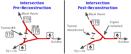
- Abandoned Tunnel #4 South End and North End.
These two photos show the boarded up Tunnel #4, which was abandoned
when the SH 119/US 6 intersection was reconstructed in the late 1990s.
At the south end the bridge over Clear Creek and the road approach have
been removed, while at the north end the road approach and bridge over
North Clear Creek remain. March 2005
- Black Hawk. Northbound on SH 119 in Black Hawk. Off to the left side you can see a parking structure for a casino. (January 2004)
- Grays and Torreys Peaks at SH 46.
Southbound on SH 119 at the SH 46 intersection, with a little fall
color in addition to the 14ers Grays Peak and Torreys Peak in the
horizon. Photo by David Herrera. (October 2012)
- South of Nederland.
Looking north along SH 119 in a peaceful valley about a half mile north
of the SH 46 intersection. This scenery is typical of the Peak to Peak
Highway. (January 2004)
- 10% Grade. I hope your brakes work, because you need them heading east down Boulder Canyon. (September 2008)
- Boulder Canyon. This shot shows a typical view of Boulder Canyon heading east down SH 119. (September 2008)
- Boulder Canyon Tunnel. Eastbound on SH 119 this tunnel bypasses a horseshoe curve in the canyon. (September 2008)
- SH 93 Intersection. Here SH 119 approaches the SH 93 intersection at Broadway in downtown Boulder. (September 2008)
- SH
119 WB at SH 157. Westbound SH 119 approaching SH
157. Sorry about the blurriness, but the sign says
"[157] SOUTH Foothills Parkway" in the left
panel, and "[119] Diagonal Highway" in the right
panel. The bridge going carries 47th St. over SH 157-119.
(July 1998)
- SH
119 Wide Median. This is SH 119 at Niwot Rd. I am
facing southeast on Niwot, while the southwestbound lanes
of 119 go left-right. The median is so wide at this point
you can't see the next set of lights for the
northeastbound lanes off in the distance. (December
1997)
History:
SH 119 is an original 1920s state highway, and went from
Idaho Springs north via Virginia Canyon to Central City,
Black Hawk, then northeast to Boulder as now. It was shifted
to its current routing southeast of Black Hawk to US 6 by
1938. The section from Boulder to Longmont was added in
1939, and was done with stairstepping, rather than a
straight diagonal shot. By 1946 SH 119 was paved from US 6
to Nederland, and by 1950 the only section not paved was
Boulder to Longmont.
By 1960 it had been straightened between Boulder and
Longmont and was paved. It was extended east from Longmont
to I-25 over the previous alignment of SH 254 by
1963. This came east out of Longmont on 3rd Avenue, so SH
119 had a short overlap along US 287. The expressway was
complete from Boulder to Niwot and Longmont to I-25 by 1975,
and from Niwot to Longmont by 1976.
In 1998, the US 6/SH 119 intersection underwent a
reconstruction to make it more friendly. Previously it was a
"triangular" intersection with US 6 going east-west, SH 119
heading north, and then a Spur SH 119 connecting to two legs
in a southeast-northwest direction. What made it interesting
was a tunnel on SH 119 just north of US 6. With the
reconstruction, the leg on the west side with the tunnel was
abandoned, and Spur 119 became part of mainline 119. The
intersection was realigned to make it a T, and a signal
installed. Tunnel #4 now has its entrances boarded up.
Here's a map to help you visualize:
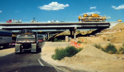
Another area of SH 119 to undergo reconstruction in the
late 1990s was the interchange at I-25. As first built it
became a very substandard diamond interchange. I-25 went
over SH 119, and the space in between the columns of the
overpass was barely two lanes wide, so four-lane 119 had to
neck down to two lanes approaching the Interstate. Traffic
backups on SH 119 and on the offramps were getting awful, so
CDOT started a project in Spring 1997 to improve the
interchange. The whole interchange was moved slightly to the
east in order to improve ramp and frontage road access.
Since there is a business district on the immediate west
side of the interchange, it had to go east. The two new
bridges built for I-25 are wide enough to accommodate the
six-laning of I-25 that will eventually occur. Here's
a picture of the construction, taken July 1998 on
eastbound 119 going under the new I-25 bridge.
On December 2, 2003, a new alignment for SH 119 east of
US 287 opened. Previously SH 119 went north on US 287 to 3rd
Avenue, then east out of town. The new expressway alignment
for SH 119 took it straight east across US 287 then
northeast up to its previous alignment.
Suggestions:
There has got to be some better signing at the
119-157 interchange. The very first time I was ever through
it going southwest on 119, I had no idea where to go, and
ended up taking 157 by default because that was the
non-exit. Some signs should be put in that say "Downtown /
Univ of Colo Via 157" or something similar. Then, direct
people going to downtown to exit at Pearl St., while people
going to CU should turn right at Arapahoe or Colorado.
|