|

|
Location: North Front Range
Length*: 19.35mi signed; 20.20mi implied
W End: Jct US 287 at Campion
E End: Jct US 85 southwest of Gilcrest
Counties: Larimer, Weld
Places: Campion, Johnson's Corner, Johnstown,
Milliken
Broken Route: SH 60 has a gap of one mile in it
from the I-25 underpass at Milepost 253 to I-25 Exit 252.
|
Milepost Guide:
- 0.00: US 287, Campion (begin SH 60 in Larimer County)
- 0.93: Begin Larimer/Weld County split
- 4.97: I-25 east frontage road (end SH 60)
- 5.82: I-25 Exit 252 interchange (begin SH
60 in Weld County)
- 11.85: SH 257, Milliken
- 20.20: US 85 southwest of Gilcrest (end SH
60)
|
Annual Average Daily Traffic (2008):
- 2700 at US 287
- 1800 at I-25 underpass, Johnson's Corner
- 9400 east of I-25
- 6200 east of SH 257, Milliken
- 4400 south of Two Rivers Pkwy
- 3600 at US 85
|
Guide:
SH 60 starts at US 287 at Campion, then heads due west on
the Larimer/Weld County Line to I-25. SH 60 has an underpass
there (I-25 Milepost 253), then ends at the east frontage
road. SH 60 starts again at the diamond interchange at Exit
252, then heads east through Johnstown and Milliken, then
abruptly takes a turn south and goes across the South Platte
River, ending at US 85.
The situation at I-25 is kinda weird. While SH 60 going
east from I-25 has a direct interchange (Exit 252), going
west from I-25 has no direct access. The next exit north
(Exit 254) is signed as "TO [60] WEST Campion". That
exit is unofficially known as Johnson's Corner due to the
truck stop there with that name. However, if you're coming
north on I-25 and are planning on taking SH 60 west, you're
better off taking the 60 East exit (Exit 252), then taking
the east frontage north one mile to where SH 60 heads west.
If you were to go up to Exit 254, you would simply be
directed to take the frontage road back south to the
underpass, resulting in two extra miles of travel.
Photo Gallery:
- SH 257 Intersection. Westbound on SH 60 at the SH 257 intersection in Milliken. Photo by Dale Sanderson. (March 2007)
History:
SH 60 is an original 1920s state highway, with the routing
the same as now. By 1939 it was paved from Johnstown to US
85, and was entirely paved by 1946. The I-25 freeway was
completed through the area about 1963, chopping SH 60 up.
Previously it had a one-mile multiplex with US 87.
Suggestions:
Section west of I-25 is better suited as a county road.
If you're not going to get rid of it, then on northbound
I-25 you should also call Exit 252 the Campion exit in
addition to Johnstown and Milliken, and say just
"[60]" instead of "[60] EAST". Northbound
Exit 254 could be called just "Johnson's Corner".
|
|
|
|
|

|
Location: North Eastern Plains
Length*: 40.99mi
S End: Jct US 34 at Dade Ave. and 1st St. in Otis
N End: Jct US 6 just east of Sterling
Counties: Washington, Logan
Places: Otis
Milepost Guide:
- 0.00: US 34, Otis (begin SH 61 in Washington County)
- 21.71: Enter Logan County
- 40.99: US 6 (end SH 61)
Annual Average Daily Traffic (2008):
- 920 at US 34, Otis
- 430 north of CR 48
- 810 north of CR 4
- 2400 at US 6
History:
SH 61 is an original 1920s state highway numbered via the
loose geographical system that existed on the Eastern Plains. Its alignment originally was from
US 36 west of Cope north via Otis and northwest via Kelley
(at Logan CR 6/57) to SH 14/US 38 east of Sterling. By 1930 the routing of US 38 east of Sterling had changed and SH 154
was run over its former route, so SH 61 ended at it. By 1939 SH 61's
route between US 36 and Otis had been changed so it passed through De
Nova (Washington CR RR/20) rather than passing to the west of it. By
1940 the routing south of Sterling had changed to its modern routing so
it didn't pass through Kelly. By 1952 a portion from SH 154 south to the Washington County line has been paved.
In 1954 both ends of SH 61 changed. The section from US 36 to
Otis was turned back so it had its south end at Otis. In the north, all
of SH 154 was turned back to,
so SH 61 was extended along its former route west to end at US 6 near
Sterling. By 1957 all of SH 61 was paved.
|
|
|
|
|

|
Location: Western Slope
Length*: 23.40mi
W End: Jct SH 145 at Placerville
E End: Jct US 550 east of Ridgway
Counties: San Miguel, Ouray
Places: Placerville, Dallas Divide, Ridgway
Mountain Passes: Dallas Divide (8970ft; 5% grade
west side; 6.4% grade east side)
 Scenic & Historic Byways: San Juan Skyway Scenic & Historic Byways: San Juan Skyway  (All-American Road) (All-American Road)
Milepost Guide:
- 0.00: SH 145, Placerville (begin SH 62 in San Miguel County)
- 12.63: Enter Ouray County, Dallas Divide
- 23.40: US 550, Ridgway (end SH 62)
Annual Average Daily Traffic (2008):
- 3700 at SH 145, Placerville
- 3900 west of CR 24A
- 8100 at US 550, Ridgway
Guide:
SH 62 serves as one of the main ways to get from the east
side of the San Juan Mountains over to the west side and Telluride. It
begins at the confluence of Leopard Creek into the San Miguel River
near Placerville, and immediately begins climbing up Leopard Creek
Canyon to the northeast toward Dallas Divide. It's pretty much a
continuous uphill grade the whole way from SH 145 to the summit.
After cresting Dallas Divide SH 62 drops down along Cottonwood Creek
and Dallas Creek toward Ridgway. It comes east through town on Sherman
Street and ends at US 550 on the east side.
There's not much settlement along SH 62. There's endless forest, but most of its length is devoid of homes and development.
History:
SH 62 is an original 1920s state highway. No major alignment
changes. By 1949 it was all paved except for Dallas Divide,
and that was paved by 1954.
|
|
|
|
|

|
Location: North Eastern Plains
Length*: 56.41mi
S End: Jct US 36 at Anton
N End: Jct US 6 at Atwood
Counties: Washington, Logan
Places: Anton, Akron, Atwood
|
Milepost Guide:
- 0.00: Jct US 36, Anton (begin SH 63 in Washington County)
- 29.00: US 34, Akron
- 48.20: Enter Logan County
- 53.29: I-76 Exit 115 interchange south of
Atwood
- 56.41: US 6, Atwood (end SH 63)
|
Annual Average Daily Traffic (2008):
- 340 at US 36, Anton
- 370 north of CR 17
- 780 north of CR 36
- 1600 south of US 34, Akron
- 640 north of CR 51
- 660 south of I-76
- 2000 at US 6, Atwood
|
Photo Gallery:
- Atwood Rail Crossing. Looking south from US 6 at SH 63's BNSF rail crossing as a train approaches. (May 2007)
- End 63/US 6 Signs. Signs at the US 6 intersection for northbound SH 63 traffic. (May 2007)
History:
SH 63 is an original 1920s highway numbered via the loose
geographical system. At first, SH 63 had its south end at SH
96 at Haswell, and went north via Boyero, Arriba, Thurman
and Akron to Atwood. By 1939 there were spurs added at each
end, from Atwood westward and from Haswell south to US 50
near Fort Lyon. By 1946 part of SH 63 had been turned back
so that there was a gap from north of Haswell to south of
Boyero. By 1954 the route was trimmed significantly so that
it went only from Anton to Atwood. Was all paved by 1961.
Dale Sanderson reports in December 2003 that when one
exits I-70 to CR 43 at Arriba, the street names signs call
the road "CR 43 / Hwy 63". That's interesting, considering
that hasn't been part of SH 63 since about 1954.
|
|
|
|
|

|
Location: North Western Slope
Length*: 73.70mi
W End: Jct US 40 at Brontosaurus Blvd. and
Stegosaurus Fwy in Dinosaur
E End: Jct SH 13 west of Meeker
Counties: Moffat, Rio Blanco
Places: Dinosaur, Rangely, Meeker
Scenic & Historic Byways: Dinosaur Diamond (US 40 to SH 139)
|
Milepost Guide:
- 0.00: US 40, Dinosaur (begin SH 64 in Moffat County)
- 1.84: Enter Rio Blanco County
- 19.79: SH 139, Rangely
- 73.70: SH 13 (end SH 64)
|
Annual Average Daily Traffic (2008):
- 1800 at US 40, Dinosaur
- 1400 west of CR 21
- 6600 at White Ave., Rangely
- 2000 east of SH 139
- 1200 east of CR 65
- 1400 east of CR 5
- 3600 at SH 13
|
Guide:
SH 64 serves as
Rio Blanco County's major east-west road, connecting the county's two
main towns, Rangely and Meeker. After starting at US 40 in Dinosaur, it
heads southeast to Rangely, passing through town on Main Street. From
Rangely, SH 64 follows the White River valley all the way to Meeker,
ending at SH 13 a couple miles west of town. Along the way it passes
Kenney Reservoir.
Photo Gallery:
- Central Rangely. Westbound on Main Street in the middle of town. (January 2009)
- Entering Rangely.
Using a lot of the camera's zoom to look all the way through Rangely
and out the other side of town, as one enters on westbound SH 64.
(January 2009)
- Kenney Reservoir. Taylor Draw Dam holds back Kenney Reservoir. Here eastbound SH 64 skirts along its frozen-over south shoreline. (January 2009)
- Milepost 41. Scenery on eastbound SH 64, about a half-hour from Meeker. (January 2009)
- SH 13 Approach. Good shot of the marker signs on SH 64 approaching the SH 13 intersection outside Meeker. (January 2009)
History:
SH 64 is an original 1920s highway. At first, however, it
continued west from south of Dinosaur into Utah, rather than
turning north toward Dinosaur. By 1939 a spur was added that
went from Meeker southeast. By 1946 the west end was moved
to US 40. The spur east of Meeker was eliminated by 1954,
and by 1955 all of SH 64 was paved.
The
town at the western end of SH 64 is not shown on maps until the 1940s.
At first it's called Sand Springs, then when it incorporated in 1947 it
was named Artesia, and then renamed to Dinosaur by 1965 to capitalize
on nearby Dinosaur National Monument. |
|
|
|
|

|
Location: Western Slope
Length*: 61.38mi
SE End: Jct SH 92 northeast of Delta
NW End: Jct I-70 Exit 49 northeast of Palisade
Counties: Delta, Mesa
Places: Orchard City, Cedaredge, Skyway, Mesa
Scenic & Historic Byways: Grand Mesa (Cederedge to I-70)
|
Milepost Guide:
- 0.00: SH 92 (begin SH 65 in Delta County)
- 29.96: Enter Mesa County
- 51.16: SH 330 north of Mesa
- 61.38: I-70 Exit 49 interchange (end SH 65)
|
Annual Average Daily Traffic (2008):
- 7800 at SH 92
- 6000 north of CR 21
- 820 north of CR U.50
- 440 north of CR AA.50
- 1800 south of SH 330
- 2300 at I-70
|
Guide:
SH 65 has four distinct sections to it. They are the Orchard
City-Cedaredge area, south Grand Mesa, north Grand Mesa, and Plateau
Creek canyon.
From SH 92, SH 65 heads north across the flat plain of Surface
Creek and surrounding fruit country. If it's the right time of the
year, expect to see lots of fruit stands along the road. Orchard City
is large as far as geogrpahic area, extending almost the entire
distance from SH 92 to the south limits of Cederedge. Not a very dense
city, though. In Cedaredge, SH 65 passes north through town on Grand
Mesa Drive, skirting the east side of downtown.
After leaving Cedaredge, SH 65 begins climbing the south face
of Grand Mesa. There are several not-very tight switchbacks as it goes
up the grass-filled south slope. Eventually it reaches an elevation
where the trees become more dense and enters Grand Mesa National
Forest. The top of Grand Mesa levels out at about elevation 10,600',
and SH 65 spends a couple miles going across alpine meadows on the
somewhat flat top. There's also a National Forest visitors center.
After crossing into Mesa County SH 65 begins descending the
north side of Grand Mesa. The north side has much more in the way of
switchbacks and drop offs than the south side does, but straightening
out near Powderhorn Ski Area. From Powderhorn north to the crossroads
town of Mesa, SH 65 continues a fairly steep descent, but on a straight
alignment.
North of Mesa at the SH 330 intersection, SH 65 takes an
abrupt curve to the west and enters into the canyon for Plateau Creek.
SH 65 follows the canyon west down to I-70, a twisty, slow alignment
surrounded by towering canyon walls. About 3/4 mile from I-70, a ramp
to eastbound I-70 splits off and stays on the north side of Plateau
Creek (SH 65's historic alignment) while mainline SH 65 crosses over to
the south side of the creek and intersects I-70 with a 3/4 diamond
interchange.
Photos:
- Jct SH 92 Signs. Sign assembly on SH 65 approaching the SH 92 intersection. (September 2011)
- Cedaredge. Southbound on SH 65 as it cruises through Cedaredge. (September 2011)
- South Slope Grand Mesa Descent. Southbound on SH 65 as it descends the slope of the south side of Grand Mesa north of Cedaredge. (September 2011)
- Top of Grand Mesa. Southbound on SH 65 on the top of Grand Mesa as it spends a couple miles crossing flat alpine meadows. (September 2011)
- Northbound Grand Mesa Descent. A view down northbound SH 65 as it descends the north side of Grand Mesa. (September 2011)
- Southbound Climb Up Grand Mesa Picture 1 & Picture 2.
Two pictures as southbound SH 65 climbs up the north side of Grand
Mesa. At times it's a tree-lined route, other times it's on the side of
a cliff. (September 2011)
- Grand Mesa National Forest. This sign greets southbound SH 65 travelers on the north slope of Grand Mesa. (September 2011)
- There are Moose Outside Alaska.
Yes, there are some moose on Grand Mesa, so CDOT makes note of it as SH
65 begins climbing the north slope of it south of Mesa. Ski runs for
Powderhorn Ski Area can be seen behind the sign. (September 2011)
- Mesa.
Southbound SH 65 heading through the crossroads town of Mesa. The store
on left offers guns, pizza, drinks and "Mom's fudge". Interesting
combination. (September 2011)
- SH 65 Destinations. This sign faces drivers coming to the stop on SH 330. (September 2011)
- Plateau Creek Canyon Eastbound and Westbound.
SH 65 between I-70 and SH 330 features views like this as it winds its
way through the deep canyon of Plateau Creek. (September 2011)
History:
SH 65 is an original 1920s state highway. At first, what is
now SH 330 started off as a
spur of SH 65. By 1939, SH 65 was extended from Delta
southeast to SH 90 along US 50's southwest side, and the spur was renumbered to SH
330. By 1947 SH 65 was paved from SH 92 to Cedaredge, and
then by 1954 the south end was trimmed back to SH 92 and
more paving was done from US 6 to Mesa. The last section to
be paved was south of Mesa in the mid 1960s.
Realignment to the south side of Plateau Creek at I-70 happened in 1965.
|
|
|
|
|

|
Location: North Front Range
Length*: 22.69mi
W End: Jct US 36 east of Lyons
E End: Jct US 85 in Platteville
Counties: Boulder, Weld
Places: Lyons, Hygiene, Longmont, Platteville
|
Milepost Guide:
- 28.69: US 36 east of Lyons (begin SH 66 in Boulder County)
- 36.62: US 287, Longmont
- 38.92: Enter Weld County
- 42.73: I-25 Exit 243 interchange northeast of
Longmont
- 51.23: BR US 85/Main St., Platteville
- 51.38: US 85, Platteville (end SH 66)
|
Annual Average Daily Traffic (2008):
- 8100 at US 36, Lyons
- 9800 east of 75th St
- 21,900 west of US 287, Longmont
- 11,600 east of I-25
- 5800 east of CR 19
- 6000 at US 85, Platteville
|
Roadway Names: Ute Road in Boulder County east of
Lyons.
Guide:
SH 66 is a very
important highway in the North Front Range, serving a lot of
traffic. The western end is a T intersection with a signal
light at US 36, and one can go straight going from 36
southeastbound to 66 eastbound. Between US 287 and I-25
(Exit 243) it has an oddball speed limit of 60mph, and is
65mph east of I-25. Personally, I've used SH 66 when going
from Fort Collins to Boulder as a bypass of the awful
congestion in central Longmont, by taking 66 west from 287
to Hover Street, then that south to SH 119.
Photo Gallery:
- SH 66
(Former Estes Park Section) South End. SH 66's (Estes Park
section) south end, as shot by Dale Sanderson. Dale says:
"In the attached photo, we're looking south on 66. The
bridge in the middleground is where the Big Thompson
exits Moraine Park, crosses under the highway, and begins
flowing alongside the road (towards the camera). That
river may form the north boundary of YMCA property - I
don't know."
- Unusual "Highway 66" Marker.
After the Estes Park section of SH 66 was turned back, apparently the
name of the road was kept as Highway 66 rather than becoming a county
road number or something. This is the marker on US 36 that replaced the
state highway marker. You normally don't ever see a marker like this in
Colorado. (August 2008)
History:
SH 66 is an original 1920s state highway. It originally
started at US 87 in north Longmont, then went to
Lyons, then via current US 36 ending in east Estes Park.
Longmont to Platteville routing was not a state highway.
Also, the section just west of US 87 originally was
shifted a little further south, so that it first went west
on 17th Ave. to Hygiene, then north on 75th St., then west
on its current route. The section from Longmont to
Platteville was added by 1939, and was paved from Estes Park
to Longmont. By 1946 it was shifted to the north west of
Longmont so that it didn't go through Hygiene. By 1954 the
only section not paved was from SH 185 (current I-25)
east to Platteville, and that was paved by 1960.
Okay, now for trying to explain the former Estes Park section. I
finally managed to figure this out thanks to several lengthy
e-mails with Ed Breed. Basically it all has to do with an
entrance station into RMNP moving. Here are some maps to
help with the explanation, showing the area between Estes
Park and RMNP. The dashed blue line is the Big Thompson
River.
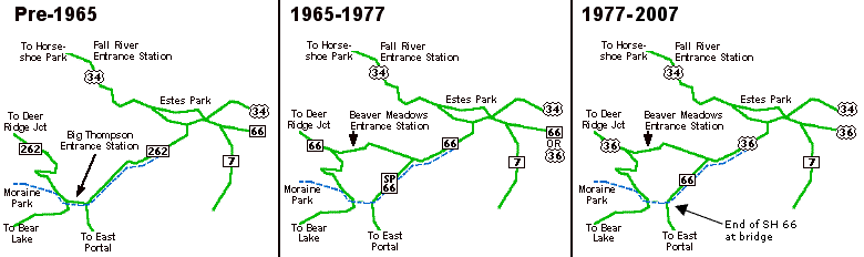
SH 66 was extended westward from Estes Park to Deer Ridge
Junction when the new Beaver Meadows Entrance Station opened
to RMNP. Previously, SH 262 had taken the route from
Estes Park to to Deer Ridge Junction, but that was via the
now-defunct Big Thompson Entrance Station near Moraine Park
(see left map). With the opening of the new entrance station
in 1960, SH 66 was extended along old SH 262, and
then what was SH 262 from the new roadway to the old
entrance station and the bridge over the river became
Spur SH 66 (see middle map), although according to
maps the 262 to 66 renumbering didn't happen until around
1964-1965. Maybe the maps lagged a few years behind the
changes out in the field.
In
1967, the Denver-Boulder Turnpike became free and US 36 was extended to
US 34 at east Estes Park and took over SH 66's route from Lyons to
Estes Park. US 36 was again extended in 1977, from east Estes Park to
Deer Ridge Junction, taking over another part of SH 66 (see right map).
The result of the 1977 renumbering was leaving the stand-alone Estes
Park section of SH 66 hanging all by itself. It totaled *1.41mi from US
36 up to the Big Thompson bridge. That section of SH 66 was turned back
in spring 2007 as part of the North Front Range route swap. Suggestions:
Needs to be widened from US 36 to I-25, particularly for
3 or so miles west of US 287.
|
|
|
|
|

|
Location: South Front Range > Central Mountains > South Metro
Denver
Length*: 77.95mi
S End: Jct SH 96 at Wetmore
N End: Jct US 85 at Sedalia
Counties: Custer, Fremont, Teller, Douglas
Places: Wetmore, Florence, Victor, Cripple Creek,
Divide, Woodland Park, Deckers, Sedalia
Triple Broken Route: Used to be continuous, but
three separate sections were turned back to the respective
local governments.
South Section
Length*: 15.00mi
S End: Jct SH 96 at Wetmore
N End: Jct US 50 north of Florence
Milepost Guide:
- 0.00: SH 96, Wetmore (begin SH 67 in Custer County)
- 1.58: Enter Fremont County
- 11.05: East jct SH 115, Florence
- 11.56: West jct SH 115, Florence
- 15.00: US 50 north of Florence (end SH
67)
|
Victor Section
Length*: 5.16mi
S End: Victor Ave. and 4th St. in Victor
N End: Cripple Creek south city limits
Milepost Guide:
- 45.56: Victor Ave./4th St., Victor (begin SH
67 in Teller County)
- 50.72: Cripple Creek city limits (end SH 67)
|
Cripple Creek-Deckers Section
Length*: 47.70mi
S End: Cripple Creek north city limits
N End: Jct Jefferson CR 126/Douglas CR 67 at
Deckers
Milepost Guide:
- 52.34: Cripple Creek city limits (begin SH
67 in Teller County)
- 69.65: West jct US 24, Divide
- 76.92: East jct US 24, Woodland Park
- 87.14: Enter Douglas County
- 100.04: CR 126/67, Deckers (end SH 67)
|
North Section
Length*: 10.09mi
S End: Intersection of Douglas CR 67 and Rampart
Range Road
N End: Jct US 85 at Sedalia
Milepost Guide:
- 117.35: Rampart Range Road (begin SH 67 in Douglas County)
- 126.73: SH 105
- 127.44: US 85, Sedalia (end SH 67)
|
NHS: While concurrent with US 24 from Divide to Woodland Park
Expressway: Five-lane undivided with US 24 from Divide to Woodland Park
Scenic & Historic Byways: Gold Belt Tour (Victor to Cripple Creek)
Memorial Desginations: POW/MIA Memorial Highway (Cripple Creek to Divide)
Annual Average Daily Traffic (2008):
|
South Section
- 1400 at SH 96
- 1600 north of CR 51
- 4400 south of SH 115, Florence
- 7000 on SH 115-67
- 2600 north of SH 115
|
Victor Section
- 1300 in Victor
- 910 north of Victor
|
Cripple Creek-Deckers Section
- 4200 north of CR 82
- 5300 south of US 24, Divide
- 8400 north of US 24, Woodland Park
- 1800 north of CR 75
- 560 at Deckers
|
North Section
- 1100 at Rampart Range Rd.
- 1700 north of Oak Valley Rd.
- 6400 at US 85, Sedalia
|
Guide:
Yep, this is a weird route. Wetmore to Sedalia, but three
sections have been turned back to local governments.
From Wetmore and SH 96, SH 67 goes 15mi north, coming into Florence on
Robinson Avenue. It turns left on Main St overlapping with SH 115 for
several blocks, then turns north on Pikes Peak Avenue out of
town. The south section ends at a US 50 intersection north of Florence.
The section as Fremont CR 67/Teller CR 86, a.k.a. Phantom Canyon Road,
is 31mi from US 50 to Victor, following an extremely curvy, slow, old narrow-guage railroad
alignment.
From
Victor SH 67 heads northwest through very mountainous
terrain passing the huge Victor-Cripple Creek gold mine, whose leach
piles dominate the skyline for awhile. At Arequa Gulch SH 67 crosses
the gulch via an impressively high, 1200 foot-long brige. Cripple Creek
occupies a relatively flat part of terrain, with SH 67 coming north
into town on 2nd St. However, the section inside the city limits was
turned back so SH 67 technically ends at the south city limits.
If one continues north on 2nd, then turns east on Bennett Ave,
following the former route of SH 67, it starts again at the north city
limits and climbs up
via several switchbacks northeast out of town.
Most of the distance from north of Cripple Creek to Divide is
spent in windy, mountainous terrain, generally not following any
defined canyons. At one point SH 67 passes through a large rock cut
that bypasses the old one-lane Waters Tunnel it used to go through.
Eventually SH 67 comes to level terrain and heads straight north to an
intersection with US 24 at Divide.
SH 67 turns east along US 24 to Woodland Park, then takes a
turn north off US 24. SH 67 follows the Trout Creek valley for awhile
north of Woodland Park, then jumps over to the West Creek Canyon, which
it follows northwest to the town of Deckers. "Town" is used rather
loosely here, since Deckers is only a couple of buildings. Deckers
falls on the Jefferson/Douglas County line on the South Fork of the
South Platte River, so the intersection SH 67 ends at is Jefferson CR
126/Douglas CR 67.
Douglas CR 67 is 17mi long along
Sugar Creek Road, and then SH 67 starts again at Rampart
Range Road and heads northeast to US 85 at Sedalia. The
first couple of miles northeast of Rampart Range Road are
slow going with a couple of sharp curves and a steep grade.
Photo Gallery:
- End SH 67 at Wetmore. An informative series of signs on southbound SH 67 approaching SH 96. (May 2013)
- North of Wetmore. The scene on northbound SH 67 a couple miles north of Wetmore. Way off in the distance is Pikes Peak. (May 2013)
- Bridge Detour.
About five miles north of Wetmore a bridges was damaged by a flash
flood in July 2012, and a detour was built to get traffic around the
bridge site while the bridge was rebuilt in 2013. As seen on northbound
SH 67 the detour uses some 20-mph curves to the east side of the
bridge. (May 2013)
- SH 67-115 Downtown Florence. The scene on Main Street eastbound through downtown Florence. (September 2012)
- Approaching SH 115 Intersection. Southbound on Pikes Peak Ave in downtown Florence as SH 67 approaches the left turn at Main St. (September 2012)
- Victor. Southbound SH 67 as it comes into Victor. (September 2010)
- Gold Mine Tailings Pile.
Here north of Victor, this tailings pile from the gold mine totally
fills the skyline. Gold mining is messy business, as this pile has a
cyanide solution dripping down through it. (September 2010)
- Bennett Ave, Cripple Creek (no longer part of SH 67). Things are hopping in Cripple Creek on this Saturday afternoon. Westbound at 3rd St, on southbound SH 67. (September 2010)
- Cripple Creek Split Level Street (no longer part of SH 67). This median in Cripple Creek, from 3rd to 4th Sts, separates Bennett Ave into two different elevations. (September 2010)
- Two Ways to Victor.
At CR 81 north of Cripple Creek, drivers on southbound SH 67 get
informed of the two ways to Victor: Right via SH 67 or left via CR 81.
The sign features a rarely seen county pentagon on a guide sign.
(September 2010)
- Fall Colors North of Cripple Creek. The scenery on northbound SH 67 north of Cripple Creek during the height of fall colors. (September 2010)
- Waters Tunnel: Bypass Road • South Portal • Interior at South Portal.
The one-lane Waters Tunnel was bypassed in 1993 (see History below).
The bypass road is visble off to the left curving around the tunnel.
Looking through the portal one can still see interior beams, guardrail,
reflectors and light fixtures. (September 2010)
- South of Divide. Southbound on SH 67 in the mountainous section between Divide and Cripple Creek. (September 2010)
- Northbound Approaching US 24. Markers on SH 67 as it comes up to US 24 at Divide, showing the overlap to the east. (September 2010)
- East of Divide. As seen on eastbound US 24/SH 67, it has a five-lane undivded section. (May 2013)
- Woodland Park SH 67 Intersection. The eastbound US 24/SH 67 split features this large destination sign. (September 2010)
History:
SH 67 is an original 1920s state highway, and at first
it had no gaps in it. By 1938 the first section of it was
paved, from Cripple Creek to Victor, and by 1946 more paving
was complete from US 24 south for about 8mi. By 1954 two
sections of SH 67 had been turned back, resulting in gaps
from Florence to Victor and Woodland Park to Rampart Range
Road. In 1957 the section between Florence and US 50 was
brought back into the system, and SH 67 was all paved by
1958. The section from Woodland Park to Deckers was brought
back by 1968.
North of Cripple Creek SH 67 used to go through the 475-foot, timber-supported Waters Tunnel.
Named for Jessie Waters, superintendent of the Midland Terminal
Railway, it was built in 1893 as the railroad pushed toward Cripple
Creek. The railroad ceased operations in 1931 and the tunnel was
converted to use for SH 67 in 1949. It remained as a one-lane tunnel
for cars until 1993 when there was a partial collapse. SH 67 was
rerouted via a new rock cut around the tunnel, and today the south
portal of the tunnel is accessible to walk right up to. Through the
bars on the door sealing it off you can still see the timber supports,
lights, side guardrail and reflectors.
Between Victor and Cripple Creek SH 67 was realigned in 2001
to let the Victor-Cripple Creek mine take over more terrain. This was
when the large Arequa Gluch bridge was built.
A major flash flood hit SH 67 south of Deckers on July 7,
2006. West Creek destroyed at least 30 sections of a 5-mile segment of
SH 67 between Deckers and Westcreek. CDOT bid out emergency
repairs to get a one-lane emergency and resident access road open by
August 7, and the fully-repaired road reopened to general traffic
October 27. The repairs, by Sema Construction, cost $11M which was
under budget, and finished ahead of schedule.
North of Wetmore a flash flood hit an SH 67 crossing on July
31, 2012, causing an old timber bridge to sag downward 5 feet. A detour
was built and opened August 24 to move traffic around the site. The
bridge was rebuilt in 2013.
In 2013 CDOT turned back the entire length of SH 67 within the
town limits to Cripple Creek, creating a 1.6 mile gap in SH 67 through
town.
|
|
|
Location: West Metro Denver
W End: Up to 1939: Jct US 40 southwest of Lookout
Mountain; 1939 to 1953: Jct SH 103 at Echo Lake
E End: Jct US 40 at Golden Rd. and Colfax Ave.
Places: Echo Lake, Squaw Pass, Bergen Park, Lookout
Mountain, Golden
History:
Appears
to be an original 1920s state highway. Started at US 40, and headed
northeast via Lookout Mountain Road to Golden, then southeast via
Golden Road to Colfax. In 1939 it was extended westward from Bergen
Park over Squaw Pass via what had been SH 74 (current SH 103) ending at
SH 103 at Echo Lake. Decommissioned in its entirety by 1954, with some
pieces of it becoming SH 103 and SH 74. |
|

|
Location: North Front Range
Length*: 4.46mi
W End: Jct US 287 at Harmony Rd. and College Ave. in
Fort Collins
E End: Jct I-25 Exit 265 west of Timnath
History:
Became
a state highway about 1968, using Harmony Road across the the south
side of Fort Collins between US 287 and I-25. Expressway from US
287 to just west of I-25 by 1971. Eventually became one of Fort
Collins' main gateways and a major commercial corridor. The expressway
was extended through the I-25 interchange, by widening the bridge and
adding turn lanes, in 2000. CDOT turned back all of SH 68 to Fort Collins in mid-2005.
Photo Gallery:
- SH
68/I-25 Old Bridge. Eastbound SH 68 just west of
I-25, where it used to neck down to go onto the two-lane
overpass. You can't see it very well, but note the narrow
bridge and no turn lanes. This is before reconstruction
that widened the bridge. (July 1998)
|
|

|
Location: South Front Range > Southeastern
Mountains
Length*: 82.66mi
SE End: Jct BL I-25 north of Walsenburg
NW End: Jct US 50 at Texas Creek
Counties: Huerfano, Custer, Fremont
Places: Walsenburg, Gardner, Westcliffe, Texas Creek
|
Milepost Guide:
- 0.00: BL I-25 north of Walsenburg (begin SH
69 in Huerfano County)
- 42.16: Enter Custer County
- 58.70: SH 96, Westcliffe
- 71.72: Enter Fremont County
- 82.66: US 50, Texas Creek (end SH 69)
|
Annual Average Daily Traffic (2008):
- 970 at BL 25
- 640 northwest of CR 632-543
- 490 northwest of CR 550
- 560 northwest of CR 310
- 3800 northwest of SH 96, Westcliffe
- 1400 north of CR 215-175
- 460 at US 50
|
Guide:
SH 69 starts at BL 25 just south of the Exit 52
interchange and heads northwest along the base of the foothills then
turns west along the Huerfano River, toward Gardner. It then heads
northwest up Muddy Creek, and once crossing over Promontory Divide
enters the Wet Mountain Valley. In the valley the jagged Sangre de
Christo Mountains dominate the horizon to the west.
SH 69 then comes north into Westcliffe on 6th St, turns left
at SH 96/Main St and right at 3rd St to go north out of town. It
continues northwest through the Wet Mountain Valley, but eventually
picks up Texas Creek and follows that north into the Arkansas River
canyon and ends at US 50. The "town" of Texas Creek is just a
whitewater raft company's building.
Photo Gallery:
- Greenhorn Mountain.
View on northbound SH 69 at about Milepost 3, with Greenhorn Mountain
dominating the skyline. Photo by David Herrera. (December 2010)
- Milepost 35, Humboldt Peak.
Another view on northbound SH 69, about 11 miles northwest of Gardner.
Here the Sangre de Christo's Humboldt Peak is prominent. Photo by David
Herrera. (December 2010)
- SH 96 Intersection View 1 and View 2. Two views on northbound SH 69 approaching the SH 96 intersection in Westcliffe. It's a palindrome! (May 2013)
- Downtown Westcliffe Right Turn. Signs on northbound SH 69 where it turns north from Main to 3rd Street in Westcliffe. (May 2013)
- North of Westcliffe. The scenery on northbound SH 69 in the Wet Mountain Valley 5 miles north of Westcliffe. (May 2013)
- South of US 50. On northbound SH 69 about 4 miles south of US 50, with the topography chaning to rocky canyons. (May 2013)
- US 50 Junction. On SH 69 as it drops down into the Arkansas River canyon at US 50. (May 2013)
History:
SH 69 is an original 1920s state highway, just as it is now,
but with the south end at US 85-87. By 1939 a spur had been
added which went southwest from US 85-87 at Walsenburg. By
1949 it was paved from US 85-87 to Del Carbon. By 1954 a
portion in the middle had been turned back, resulting in a
gap that went from 13mi northwest of Gardner to Westcliffe,
and the spur southwest of Walsenburg was gone. By 1958 the
only portion not paved was from Gardner northwest to the
start of the gap. The gap was then closed in 1977, and that
segment was paved in the mid 1980s. While SH 69 had the gap
in it, SH 69 and SH 96 ended at each other in Westcliffe.
|
|
|
Location: Metro Denver
History:
SH 70
is an original 1920s state highway. It appears it at first went from
Morrison east via Hampden Ave to Fort Logan, then east to Santa Fe
Drive. The road network it used east of Morrison does not exist anymore
due to Bear Creek Reservoir. By
1939 the Denver insert on CDH maps is clearer about SH 70's
routing. It started at US 285/SH 8 east of Morrison, east generally
along Hampden Ave, but used Kenyon Ave past Fort Morgan to Lowell, then
Hampden Ave again east to Yosemite St. East of that SH 70 crossed
Kenwood Dam across Cherry Creek, then north via Havana St from Parker
Rd to US 6 (current SH 2), and north via Sable Blvd to Brighton.
By 1949 the section
from Smith Road north to US 6 was turned back (part of that making way for the Rocky Mountain Arsenal). By 1950 Kenwood Dam was
gone, replaced by the modern Cherry Creek Dam, so SH 70's exact routing in southeast metro is unknown.
By 1954, SH 70 started at Hampden/Sheridan, went
east to Yosemite, then started again at Parker/Havana and
went north to Colfax, and had a third section along Sable
between US 6 and Brighton. By 1957 SH
70 began to resemble the urban expressway of today. The
downtown Englewood south bypass along Jefferson Avenue was
in place, as was the sweeping curve making SH 70
continuous from Hampden onto Havana.
By 1963 the Hampden interchanges were in at Sheridan, Federal and
Santa Fe. During the rest of the 1960s the freeway was
extended westward from Sheridan. It reached Estes Street by
1965, and Kipling by 1967. US 285 was moved off of Morrison
Road and onto the Hampden/Havana freeway/expressway about
1969 taking over that part of SH 70. The section of
SH 70 south of Brighton along Sable was renumbered to
SH 51 in the purge of 1968.
|
|

|
Location: Western Slope > Central Mountains
> Metro Denver > Eastern Plains
Length*: 449.59mi
W End: Utah
border west of Grand Junction
E End: Kansas
border east of Burlington (link to Richie Kennedy's
site)
Nationally: W End: Jct I-15 at Fort Cove, Utah; E
End: Baltimore, Maryland (2175mi)
Counties: Mesa, Garfield, Eagle, Summit, Clear
Creek, Jefferson, Denver, Adams, Arapahoe, Elbert, Lincoln,
Kit Carson
Places: Fruita, Grand Junction, DeBeque Canyon, DeBeque,
Parachute, Rifle, Silt, New Castle, Glenwood Springs,
Glenwood Canyon, Gypsum, Eagle, Edwards, Avon, Vail, Vail
Pass, Frisco, Silverthorne, Dillon, Eisenhower Tunnel,
Silver Plume, Georgetown, Idaho Springs, Mount Vernon
Canyon, Wheat Ridge, Denver, Aurora, Byers, Deer Trail,
Limon, Genoa, Arriba, Flagler, Seibert, Vona, Bethune,
Burlington
See the separate page for
I-70 for the remainder of the info. Looking just for
exit lists?
Related Sites:
|
|

|
Location: Slater (Moffat County)
Length: 0.90mi in Colorado
Notes:
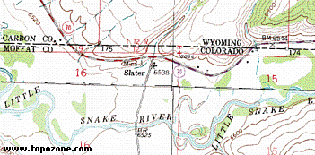 Wyoming
70, on its journey from Baggs east through Carbon County to
Encampment, for 0.90 mile dips south across the state line
into Colorado (mileposts 15.34 to 16.24). This occurs at
Slater, Colorado, a locale at the junction of Wyoming 70 and
Moffat CR 1, near the confluence of Slater Creek and the
Little Snake River. This section of highway, while in
Colorado, is maintained by the Wyoming DOT. Wyoming
70, on its journey from Baggs east through Carbon County to
Encampment, for 0.90 mile dips south across the state line
into Colorado (mileposts 15.34 to 16.24). This occurs at
Slater, Colorado, a locale at the junction of Wyoming 70 and
Moffat CR 1, near the confluence of Slater Creek and the
Little Snake River. This section of highway, while in
Colorado, is maintained by the Wyoming DOT.
The USGS topo map at right shows the area. You can see
the border running east-west, the highway crossing into
Colorado, and the locale of Slater, which appears to consist
of two buildings and a mine shaft.
See also:
|
|

|
Location: Arkansas Valley > Eastern Plains
Length*: 232.90mi
S End: Jct US 350 southwest of La Junta
N End: Nebraska border south of Kimball, connecting
with NE
71 (Link to Chris Geelhart's site)
Nationally: SH 71 is part of Multi-State 71. N End:
Hot Springs, South Dakota
Counties: Otero, Crowley, Lincoln, Washington,
Morgan, Weld
Places: Hawley, Rocky Ford, Ordway, Punkin Center,
Limon, Last Chance, Brush, Snyder, Stoneham
NHS:
- While concurrent with US 50 through Rocky Ford
- US 24-40-287 at Limon north to Nebraska (Heartland Expressway corridor)
Scenic & Historic Byways: Pawnee Pioneer Trails (while concurrent with SH 14)
Milepost Guide:
- 0.00: US 350 (begin SH 71 in Otero County)
- 9.03: West jct SH 10, Hawley
- 9.59: East jct SH 10
- 14.53: East jct US 50/SH 266, Rocky
Ford
- 16.15: West jct US 50 northwest of Rocky
Ford
- 19.53: Enter Crowley County
- 26.64: South jct SH 96, Ordway
- 26.88: North jct SH 96/3rd St.
- 48.65: Enter Lincoln County
- 72.60: SH 94, Punkin Center
- 101.06: West jct US 24-40-287/Main St.,
Limon
|
- 101.97: East jct US 24-40-287
- 125.85: Enter Washington County
- 138.01: US 36, Last Chance
- 156.08: Enter Morgan County
- 174.35: East jct US 34, Brush
- 175.48: West jct US 34/Edison St.,
Brush
- 176.46: I-76 Exit 90 interchange north
of Brush
- 195.61: Enter Weld County
- 201.63: East jct SH 14
- 205.52: West jct SH 14, Stoneham
- 232.90: Nebraska border (end SH 71)
|
Annual Average Daily Traffic (2008):
- 250 at US 350
- 230 south of SH 10, Hawley
- 470 north of SH 10
- 2700 south of US 50, Rocky Ford
- 1600 north of US 50
- 1400 north of CR 8
- 1800 on SH 71-96, Ordway
- 880 north of CR 18
- 830 north of CR BB
- 530 north of SH 94, Punkin Center
- 790 north of CR 2Z
- 2600 south of US 24-40-287, Limon
|
- 2000 north of US 24-40-287
- 980 north of CR 3J
- 770 south of US 36, Last Chance
- 1100 north of US 36
- 980 north of CR 29
- 2300 south of US 34, Brush
- 6100 south of I-76, Brush
- 1000 north of CR W
- 380 south of SH 14
- 1500 on SH 14-71
- 580 north of SH 14
- 630 at Nebraska border
|
Guide:
This is a looonnnggg highway. It starts at US 350 southwest of La
Junta, and just north of the intersection is the Sierra Vista Overlook,
a natural hill providing a view of a large swath of Comanche National
Grassland. SH 71 goes due north to Hawley where there is a short jog to
the east along SH 10. North of Hawley SH 71 enters Rocky Ford, coming
into town and meeting US 50/SH 266 at 12th St. and Elm Avenue. SH 71
overlaps on US 50 west for 2mi then turns north and crosses over the
Arkansas River and past the east side of Ordway.
North of Ordway SH 71 is in sparse country for a long way,
cruising over the grassland and down and up across the occassional
creek valley. For the 75mi from Ordway to Limon, the only settlement
passed through is Punkin Center at SH 94, which is comprised of only a
few buildings. There are no services between Ordway and Limon.
In
Limon, SH 71 hits US 24-40-287/BL 70 at K Ave. and Main St. From there,
it goes east on Main St. through downtown multiplexed with those routes
to 1st Ave.,
where it heads north. SH 71 does not have an interchange with I-70,
instead just an overpass.
Then it's north toward Last Chance at US 36, through Woodrow, and
finally intersecting US 34 east of downtown Brush. Like the stretch
further south, there are no services between Limon and Brush.
SH 71 follows US 34
west into Brush and at Colorado Ave. downton SH 71 turns north,
goes through I-76 Exit 90, through Snyder, and north to SH 14 near Stoneham.
It goes west on SH 14 for 4mi, then heads north for 27mi to the
Nebraska border.
Photo Gallery:
- Approaching SH 10. On northbound SH 71 as it approaches the western SH 10 junction just west of Hawley. (May 2013)
- US 50, Rocky Ford.
Northbound SH 71 on 12th Street at it approaches the US 50-SH 266
junction. US 50 uses two one-way streets so there are two
intersections. (May 2013)
- Arkansas River Bridge. Northbound on SH 71 as it crosses over the Arkansas River between Rocky Ford and Ordway. (May 2013)
- North of Ordway.
The view on northbound SH 71 about 6 miles north of Ordway. The
landscape rapidly turns arid as the irrigated Arkansas Valley is left
behind. (May 2013)
- SH 94 Destinations. Large destination sign on northbound SH 71 at the SH 94 intersection. (May 2013)
- Punkin Center Sign. How can you not take a picture of it? Southbound approaching SH 94. (February 2008)
- South Rush Creek Bridge Construction, Approach and Bridge.
In early 2008 CDOT was replacing the SH 71 bridge over South Rush Creek
north of Punkin Center. A temporary bypass took traffic around the west
side of the construction zone. (February 2008)
- Limon Marker Assembly.
Northbound SH 71 where it hits Main Street in Limon. There are already
a lot of signs piled onto this marker assembly, and they didn't even
include BL 70. (February 2008)
- SH 71 at US 34.
Marker assembly on NB SH 71 at US 34 east of downtown Brush. Note it
says you can go either way to get to I-76 (which is true). (April 2004)
- Nebraska Border.
Shot north on SH 71 at the Nebraska border. Interestingly, CDOT has put
in an "end 71" sign here, although the highway continues in Nebraska as
NE 71. Photo by Bo Baize. (November 2009)
History:
SH 71 is an original 1920s highway. And
followed its current route from US 350 north to Brush. By 1939 a spur
was added which went north from Brush. By 1954 there was no spur north
of Brush, and a portion had been turned back creating a gap from 11mi
north of Limon to Last Chance. The gap was closed by 1955. By 1958 the
only portion not paved was from north of Ordway to south of Limon. The
section from Brush north to SH 14 to Nebraska was added about 1964, and
SH 71 was completely paved by 1965.
In Limon, SH 71 originally came
north to US 24-40-287 at I Avenue, but was realigned west to K Avenue
about 1999.
In Brush, the Exit 90 interchange at I-76 was originally a
cloverleaf interchange when it was built in 1959. In spring 2013 as
part of an I-76 reconstruction project it was changed to a diamond
interchange.
SH 71 suffered severe damage from South Platte flooding south
of Snyder, due to heavy rain upstream Sept 11-15, 2013. SH 71 underwent
emergency repairs and was reopened in early October 2013.
|
|
|
|
|

|
Location: Northwest Metro Denver > North
Mountains
Length*: 54.06mi
SE End: Ward Rd/44th Ave at I-70 Exit 266 in Wheat Ridge
NW End: Jct SH 7 north of Raymond
Counties: Jefferson, Gilpin, Boulder
Places: Wheat Ridge, Arvada, Wondervu, Pinecliffe,
Nederland, Ward, Raymond
Roadway Names: Section from SH 119 to SH 7 is part
of the Peak to Peak Highway.
Scenic & Historic Byways: Peak to Peak Highway (SH 119 to SH 7)
|
Milepost Guide:
- 0.00: 44th Ave (begin SH 72 in Jefferson County)
- 10.65: SH 93 west of Arvada
- 18.89: Enter Boulder County
- 21.49: Enter Gilpin County
- 24.68: Enter Boulder County
- 26.60: Enter Gilpin County
- 27.33: Enter Boulder County
- 29.37: South jct SH 119 south of Nederland
- 32.37: North jct SH 119, Nederland
- 54.06: SH 7 (end SH 72)
|
Annual Average Daily Traffic (2008):
- 35,600 at I-70, Wheat Ridge
- 20,700 west of Ward Rd.
- 15,700 north of 64th Ave.
- 4100 west of Indiana St.
- 5000 west of SH 93
- 1400 west of Camp Eden Rd.
- 880 east of SH 119
- 8300 at Boulder St on SH 119-72, Nederland
- 3200 north of SH 119
- 1100 north of Ward
- 820 at SH 7
|
Guide:
A
real two-faced highway. It starts off in an urban area between Denver
and Golden at I-70, heads north through Arvada on Ward Road, west on
64th Ave., north on Indiana St., then west on its own. At SH 93, it
goes past what's left of the Rocky Flats Plant, a DOE place that
produced really nasty pollution in the process of making parts for
nuclear weapons. It then heads west up into Coal Creek Canyon to
Wondervu. It then takes a slow, torturous course over ridges to drop
down into the canyon of Boulder Creek and passes through Pinecliffe.
Eventually SH 72 meets SH 119 south of Nederland, then the two of them
head north to town. SH 119-72 split in Nederland and SH 72 heads north
through Ward, ending at SH 7 near Raymond. Photo Gallery:
- Climbing Up Black Gulch. Eastbound SH 72 about a mile east of Pinecliffe as it climbs up the side of Black Gulch. March 2005
- Pinecliffe Rail Crossing. In this picture looking east you can see where SH 72 crosses the UPRR Moffat Tunnel line, in the town of Pinecliffe. March 2005
- SH
72/119 Roundabout Sign. Sign for the roundabout
at the SH 72/119 intersection in Nederland, here seen on
the approach to it on southbound SH 72. June 2001
History:
SH 72 is an original 1920s state highway, which probably
started at Federal Blvd. and 46th Ave in Denver (SH 1/US
285) then went northwest via some indeterminate streets,
out of the metro, up Coal Creek Canyon, ending at SH 119 at
Nederland. Section from Nederland to Raymond originally
designated SH 160. By
1936 the eastern end had been trimmed back to Sheridan
Blvd., ending at SH 58. In 1939 a new section in the
east metro was added, which went along Smith Road from
Colorado Blvd. east to Colfax Ave. (US 40) west of Watkins.
By 1946 the section from SH 93 into Denver was paved, and
link for SH 72 was added in the central metro, basically
along 46th Ave., between the two previously disjointed
sections. The original Mousetrap Interchange on the Valley
Highway was completed in 1950 as the interchange with 46th
Ave./SH 72. See I-25 or
SH 185 for more on
the Valley Highway. By 1954, additional paving had been done
from SH 93 up to the Boulder/Jefferson County line, and by
1958 was paved in its entirety up to Nederland.
In the late '50s state maps, the Denver insert finally got
good enough that it can be seen with some clarity what
streets SH 72 was using. From Coal Creek Canyon it came
south on Indiana, east on 64th and Ralston, south on Marshall, east on 46th to Federal, then used a
combination of 48th and 46th to Colorado, then Smith Road southeast to Colfax.
During the 1960s, the alignment of SH 72 along 46th and
48th Avenues in Denver began transforming into the freeway
alignment for I-70. In 1961, SH 72 continued east on the 46th Avenue alignment east to Havana St, then south to Smith Road. On September 12,
1964, the elevated 46th Avenue freeway opened from I-25 east
to Colorado Blvd. 46th Ave. was one of the "worst traffic
bottlenecks in Denver", and building the elevated freeway
was thought to be the solution.
In 1965 SH 72 was with the I-70 freeway (including through the
new Stapleton tunnel) east to Peoria St, where the freeway ended and SH
72 went south to Smith Road. 1965 also saw the addition of a spur SH 72
connection along Tower Road between Smith Road and Colfax Ave. The spur
would become SH 32 in 1968.
By 1966 more I-70 freeway had been completed, so SH 72 was
freeway with I-70 from Sheridan Blvd east all the way to Colfax Ave. At
that point it was a defacto carrier route for I-70. By 1967 the
autonomous sections off of I-70 only existed west of Wadsworth Blvd and
the spur along Tower Road, which had been extended north to I-70.
In the purge of 1968 four changes occurred to SH 72:
- SH 160 from Nederland to SH
7 was renumbered as an extension of SH 72 to avoid
duplication with US 160.
- SH 72 from Ward Rd to Wadsworth was rerouted off of Ralston Rd and instead turned south on Ward to I-70.
- The carrier route portion along I-70 from Wadsworth to east Colfax was eliminated.
- The spur connection along Tower was renumbered to SH 32.
SH
72 in Coal Creek Canyon west of SH 93 suffered severe damage from
flooding on Sept 12-15, 2013. Following emergency repairs the road
reopened on November 11, 2013.
|
|
|
Location: West Metro Denver
S End: Jct US 285 at Conifer
N End: Jct SH 74 at Evergreen
History:
SH 73 was a link from SH 74 at Evergreen south to
US 285 at Conifer. It was an original 1920s state highway.
By 1954 it was paved from Evergreen halfway south to
Conifer, and all the way to Conifer by 1958. Turned back in
1965. Current Jefferson CR 73. Street name signs along it
still say "HWY 73". Carries a lot of traffic in the bedroom
community-boondocks southwest of Denver with the SH 74/CR 73
intersection in Evergreen congested at all hours of the day.
|
|

|
Location: West Metro Denver
Length*: 18.11mi
W End: Jct I-70 Exit 252 at El Rancho
E End: Jct SH 8 in Morrison
Counties: Jefferson
Places: El Rancho, Bergen Park, Evergreen, Idledale,
Morrison
Roadway Names:
- Evergreen Parkway from I-70 to Evergreen
- Bear Creek Road from Evergreen to Morrison
Scenic & Historic Byways: Lariat Loop
Expressway:
- Four-lane divided from I-70 south to south of Bergen
Park
- Five-lane undivided from south of Bergen Park to the
west side of Evergreen
Milepost Guide:
- 0.00: I-70 Exit 252 interchange (begin SH
74 in Jefferson County)
- 0.23: US 40, El Rancho
- 18.11: SH 8, Morrison (end SH 74)
Annual Average Daily Traffic (2008):
- 20,800 at I-70, El Rancho
- 24,000 south of Bergen Pkwy., Bergen Park
- 5800 east of CR 73, Evergreen
- 3600 east of Myers Gulch Rd.
- 3200 east of Grapevine Road, Idledale
- 4300 at SH 8, Morrison
Guide:
Serves as a major feeder for people who live in the
foothills west of Denver to get to I-70. From I-70 it heads
south through El Rancho, Hidden Valley, Bergen Park, Wah
Keeney Park, and Hiwan Hills to Evergreen. There, it turns
east and follows Bear Creek through Kittredge and Idledale
to Morrison. There are numerous signal lights from I-70 to
Evergreen.
Photo Gallery:
- SH
74/US 40 El Rancho. Looking south along SH 74 at
El Rancho. (May 1999)
- SH
74 Near Bergen Parkway. The scenery looking north
along SH 74 at the south Bergen Parkway intersection, as
SH 74 swerves around the hillside off in the distance.
(May 1999)
- Downtown Evergreen.
A shot looking east down SH 74 through "downtown" Evergreen, from the
SH 74/CR 73 intersection. It's typical to not be able to find a parking
spot anywhere. (August 2004)
History:
SH 74 is an original 1920s state
highway. Started at SH 103 at Echo Lake, and went east over Squaw Pass
to Bergen Park, then to Evergreen and Morrison. Also at some
indeterminate time (possibly 1939) it was extened east from Morrison
along Hogback Road and Alameda Avenue into Denver, ending at SH 8 at
Morrison Road.
By 1940 the west end had
been shifted to SH 68 at Bergen Park, which had been extended west along SH 74's route to Echo Lake. Entirely paved by 1949.
By 1954 the west end was changed so
that SH 74 went from Evergreen west to Brookvale (along what had previously been SH 98), ending
as a spur there, and the east end was trimmed back to Morrison. By
1962 the west end was changed again and shifted north to El
Rancho. Undivided expressway from Bergen Park to Evergreen
completed by 1972. Divided expressway from El Rancho to
Bergen Park constructed in 1996.
|
|
|
|
|

|
Location: South Metro Denver
Length*: 3.24mi
N End: Platte Canyon Road & Bowles Avenue in Littleton
S End: Jct SH 470 at Platte Canyon Road southwest of
Littleton
Counties: Arapahoe, Jefferson
Places: Littleton, Columbine Valley
Roadway Names: Platte Canyon Road
|
Milepost Guide:
- 5.28: Platte Canyon/Bowles Ave, Littleton (begin
SH 75 in Arapahoe County)
- 7.73: Enter Jefferson County
- 8.52: SH 470 (end SH 75)
|
Annual Average Daily Traffic (2008):
- 18,200 south of Bowles Ave.
- 13,000 south of Coal Mine Ave.
- 6700 at SH 470
|
Notes: Odd mileposting is a leftover from its 1970s historic starting point in downtown Englewood.
Guide:
The southern end of SH 75 at SH 470 is not a full
interchange. Instead, you can only go from westbound 470 to
75, and from 75 to WB 470. SH 75 then heads north on Platte
Canyon Rd. through heavily populated unincorporated
Jefferson and Arapahoe Counties, then through Columbine
Valley. On the west side of Littleton, it ends at the intersection of Platte Canyon Rd and Bowles Ave.
History:
SH 75 is an original 1920s state highway, going along
Federal Blvd. from SH 70 (Hampden Ave.) north to US
40-87 (Colfax Ave.).
By 1939, SH 75 went from US 285 at Bailey southeast then
northeast to SH 126 at Pine, from South Platte
northeast to Waterton (a.k.a. Kassler), northeast to SH
124 (Deer Creek Road), then north to Fort Logan and
finally north on Federal, ending at 38th Ave. One segment
between Buffalo Creek and South Platte is shown as
projected/impassable.
By 1954, SH 75 went only from Hampden/Federal north to
Colfax, and in 1955 a section was added that went from
Bowles/Santa Fe southwest along Platte Canyon Rd. for 3mi.
The section along Platte Canyon was extended to 10mi long by
1956. The expressway from Deer Creek Rd. south to the then
Martin-Marietta aerospace plant opened in 1960. By 1966 the
section that had its south end at Hampden/Federal was
extended south to Belleview Ave. and east to Santa Fe.
By 1971 Federal was renumbered as part of SH
88 and SH 75 took over part of SH 87's route, so
SH 75 went from Kassler north via Platte Canyon Rd.,
Littleton Blvd., and Broadway to Hampden Avenue (US 285),
for a total of *14.36mi. The expressway remained from SH 121
south to Kassler. The route included a split along two
one-way streets, Main Street and Alamo Avenue, in downtown
Littleton.
SH 75 remained that way until 1991, when the construction
of SH 470 chopped SH 75 in half between Wadsworth Blvd. and
Platte Canyon Rd. What had previously been SH 75 from
Kassler to SH 470 was redesignated as an extension of
SH 121.
Sometime
in the late 1990s two sections of SH 75 were turned back. One was the
section through downtown Littleton from Santa Fe Drive east to
Broadway, and the other the entire Englewood section from the Littleton
border north to Hampden Ave. That left a short dangling section in east
Littleton, along Broadway from Littleton Blvd *0.47mi north to Rafferty
Gardens Ave. Why that piece, a state highway that didn't touch any
other, was left in place beats me.
The southern section of SH 75 continued to go from SH 470
northeast and east on Bowles to end at US 85 until summer 2010 when the
section along Bowles was turned back. This left SH 75's south section
with a dangling end at Platte Canyon and Bowles.
CDOT turned back the disjointed northern section along Broadway to Littleton in fall 2011.
|
|

|
Location: Southeast Mountains > South Front
Range
SW End: 1920s-1953: Jct SH 96 southwest of Wetmore;
1954-1956: Beulah; 1957-1975: Jct SH 165 southwest of
Beulah
NE End:
1920s-1958: Jct US 85-87 at Northern Ave. and Lake Ave. in south
Pueblo; 1959-1965: Jct SH 96 at Prairie Ave/Thatcher Ave in Pueblo;
1966-1975: Jct SH 45 in southwest Pueblo History:
SH 76 is the original 1920s number for current
SH 78. It originally also was the
designation for SH 165 from SH 78 northwest to SH 96. So,
from the 1920s SH 76 went from SH 96 southeast then
northeast, via Beulah, to Pueblo, ending at US 85-87
in town. By 1936 it was paved from Beulah into Pueblo. The
spur connection to Beulah (see SH 78 below) was added in
1939 and originally had a separate designation, SH
273.
By 1952, SH 76 was turned back between SH 273 and SH 165, so SH 273 and SH 76 ended at each other. By 1954 the SH 273 designation was dropped and SH 76 was extended into Beulah, ending there. By 1956 it had been extended back down to SH 165,
and Spur SH 76 into Beulah was added. In 1959 US 85-87 was moved onto what would become I-25 through Pueblo, so the east end of SH 76 was rerouted so it went north on Prairie Ave, ending at SH 96 at Thatcher Ave. By 1966 SH 45 had started to be built and SH 76's east end was trimmed back to Pueblo Blvd.
The switch from SH 76 to SH 78 occurred in 1975 in
order to avoid duplication when I-80S was switched to
I-76. The January 1, 1976 route log specifically mentions
the number switch.
|
|

|
Location: North Metro Denver > North Eastern
Plains
Length*: 184.14mi
SW End: Jct I-70 in Arvada (Exit 269)
NE End: Nebraska
border northeast of Julesburg (link to Chris Geelhart's
site)
Nationally: Continues northeast in Nebraska for less
than two miles to end at I-80 south of Big Springs (185mi)
Counties: Jefferson, Adams, Weld, Morgan,
Washington, Logan, Sedgwick
Places: Arvada, Wheat Ridge, Commerce City, Brighton,
Hudson, Keenesburg, Wiggins, Fort Morgan, Brush, Sterling,
Julesburg
For the remainder of the information see the separate I-76 page.
Related Site: I-76
(Western) @ Interstate Guide
|
|
|
Location: East Mountains
NW End: Jct US 285 at Jefferson
SE End: Jct US 24 at Lake George
Places: Jefferson, Tarryall Reservoir, Tarryall, Lake
George
History:
SH 77 is an original 1920s state highway. By 1954
a section of it had been turned back, creating a gap from
4mi northwest of Lake George to Tarryall Reservoir. Turned
back entirely by 1955.
|
|
|
Location: Central Mountains
W End: 1920s to 1939: Jct US 24-6 at Red Cliff; 1940 to 1968: Jct US 24 north of Minturn at Dowds
Junction
E End: Jct SH 91 at Wheeler Junction/Copper
Mountain
Places: Shrine Pass and later Vail Pass <>History:
SH 78 started out as an
orginal 1920s state highway for Shrine Pass Road, going from US 6-24 at
Red Cliff east over the pass and down to SH 91/US 6 at Wheeler Junction
(today's Copper Mountain). No route existed over Vail Pass, so in its
first routing westward US 6 utilized today's SH 91 and US 24 via
Leadville and Minturn to get from Frisco to Avon. However, it appears
in 1939 a road started being worked east from Dowds Junction into the
Vail Valley. It at first was a spur, SH 293.
In 1940 a reshuffling happened in the area. SH 78
was moved from Shrine Pass to Vail Pass, so went from Dowds Junction
east over Vail Pass and ending at Wheeler Junction. US 6 was moved from
its Leadville routing to along SH 78 over Vail Pass. SH 293 was moved to Shrine Pass Road.
From 1940 onward SH
78 was the defacto carrier route for US 6, and so was
decommissioned along with the other carrier routes in the
purge of 1968. The town of Vail doesn't appear on maps until 1964. |
|

|
Location: Southeast Mountains > South Front
Range
Length*: 33.27mi
SW End: Jct SH 165 southwest of Beulah
NE End: Jct SH 45 in west Pueblo
Counties: Custer, Pueblo
Places: Beulah, Pueblo
Spur Connection: To
Beulah
Notes: Nine miles of SH 78 from SH 165
northeastward is still gravel.
|
Milepost Guide:
- 0.00: SH 165 (begin SH 78 in Custer County)
- 2.40: Enter Pueblo County
- 9.10: CR 205/Begin Pavement
- 12.71: Spur SH 78 east of Beulah
- 33.27: SH 45, Pueblo (end SH 78)
|
Annual Average Daily Traffic (2008):
- 340 at SH 165
- 980 northeast of Spur 78
- 1400 northeast of CR 221
- 9000 east of La Vista Rd., Pueblo
- 17,400 at SH 45
|
Guide:
From
SH 165, SH 78 goes northeast, weaving around as it goes through the Wet
Mountains. At Pueblo Mountain Park, SH 78 switches from gravel to paved
and becomes known as Pine Drive as it passes houses on the outskirts of
Beulah. After the intersection with Spur 78, SH 78 climbs up and out of
the St. Charles River valley and maintains a fairly straight alignment
northeast across open country to Pueblo. SH 78 ends at its intersection
with SH 45 (Pueblo Blvd) on the southwest side of town.
Trucks longer than 40 feet are discouraged from traveling on the gravel portion of SH 78 due to tight switchbacks.
Photo Gallery:
- Gravel Road Up the Wet Mountains. A shot looking westbound on SH 78 at the first switchback after the pavement end. (May 2009)
- Gravel Road Next 9 Miles. At the end of the pavement west of Beulah. (May 2009)
- Pine Drive, Beulah Outskirts. Typical scene on westbound SH 78 west of the Spur 78 intersection. (May 2009)
- Truckers Better Think Twice.
Warning sign on westbound SH 78 after the Spur 78 intersection, telling
truckers they might not be able to make it around the switchbacks. (May
2009)
- Spur 78 Approach Sign 1 and Sign 2.
The two signs on westbound SH 78 approaching the Beulah spur. Note the
spur route is actually marked with a business banner even though CDOT
defines it as a spur route. (May 2009)
- North Saint Charles River Bridge. Westbound on SH 78 coming down the hill to the bridge over the North Saint Charles River east of Beulah. (May 2009)
- Milepost 29. The scenery on westbound SH 78 at Milepost 29, a few miles outside Pueblo. (May 2009)
History:
Routing is an original 1920s highway, however it used to be
SH 76. Changed to avoid a conflict when
I-80S became I-76 in 1975. See SH
76 above.
|
|
|
|
|

|
Location: North Eastern Plains
Length*: 23.89mi
S End: I-70 Exit 304 south frontage road south of Bennett
N End: Jct SH 52 at Prospect Valley
Counties: Adams, Weld
Places: Bennett, Prospect Valley
Milepost Guide:
- 0.00: I-70 south frontage road (begin SH
79 in Adams County)
- 0.16: I-70 Exit 304 interchange
- 1.24: West jct SH 36, Bennett
- 1.58: East jct SH 36, Bennett
- 18.93: Enter Weld County
- 23.89: SH 52, Prospect Valley (end SH 79)
Annual Average Daily Traffic (2008):
- 4300 at I-70
- 2600 north of SH 36, Bennett
- 1800 north of 88th Ave
- 1200 at SH 52
Photo Gallery:
- Typical
SH 79. Nortbound on SH 79 in Adams County. The
power poles stretch all the way to the horizon in this
pancake-flat area. (February 2003)
- Flash
Flood Area. Ominous sign on northbound SH 79 in
Adams County. Not much in the way of streams out here, so
I guess the water just kind of pools around, prompting
the need for this sign. (February 2003)
- End
SH 79. Northbound sign on the approach to SH 52
in Prospect Valley. (February 2003)
- SH
52 & I-76, Either Way. Sign at the
intersection of SH 79 and SH 52. (February 2003)
History:
SH 79 is an original 1920s state highway, going from
Bennett to Prospect Valley. By 1954 a spur had been added
which went from Bennett south to the Arapahoe/Elbert County
line, but that was eliminated by 1955. Was entirely paved by
1963. Extended south from Bennett to I-70 in 1963.
Suggestions:
E-mail from Joe Herter:
My Dad lives in Elbert County and according
to county planners there are attempts to pave the
Kiowa-Bennett Road and extend Colo 79 from Bennett to
Kiowa. I have not confirmed this, but in my opinion this
could offer a total bypass of Denver from I-76 to Colo
Spgs!
Robert Halonen then chimed in also on that idea, saying
he would like to see it. He would also like to see it
extended from Prospect Valley up Weld CR 73 to I-76 at
Roggen. If we expand further on this idea, SH 79 could go
even further south from Kiowa via Elbert Road to US 24
northeast of Falcon.
The last unpaved section of Kiowa-Bennett Road, south of the
Elbert-Arapahoe County line, was paved in late 2011. No extension of
any state highways happened, though.
|