Because of its isolation, road building was a concern in Colorado even in the 1860s. When Colorado became a territory in 1861, the Kansas Legislature already had authorized some toll roads and bridges, one of which was a toll bridge over the Arkansas River at Pueblo, built in 1860. Otto Mears built some 300 miles of toll roads in and around the San Juan Mountains, including what is today the Million Dollar Highway, US 550, in the 1880s.
Like the rest of the United States, Colorado went through a "good roads" movement at the beginning of the 20th Century. Bicyclists and car drivers began pushing for paved roads. The State didn't immediately jump on the chance, because some felt that the wealthy people that owned cars should build their own roads. Millionaire Spencer Penrose actually did: He bought a new car every year, and built the highway to the top of Pike's Peak. "Cement Bill" Williams started to build a paved road to the top of Lookout Mountain, but "ran out of gas" and had to let the City of Denver complete it in 1913.
In 1902, 42 auto owners formed the Colorado Auto Club. The CAC and the Colorado Chapter of the National Good Roads Association (1905) persuaded the legislature to pass a bill in 1909 to establish the Colorado Highway Commission, and it became effective Jan. 1, 1910. The only problem was the funding: The legislature allocated a measly $65,000. The Colorado highway system was established by having the counties submit maps showing their most traveled roads, and the first state primary system covered 1643.5mi. An interesting note is that the commissioners would not approve a road for inclusion in the system unless they drove on it first. By the 1920s the Colorado Department of Highways (CDH) was spending $2.5M annually on roads.
In 1916, the Federal Highway Act started the Federal Aid Primary system, with 50-50 matching funding. The first federally funded primary highways in Colorado were:
Convict labor was used extensively to build roads in Colorado beginning in 1905. The materials needed - lime, gravel, and stone - were quarried from an area conveniently located behind the state prison at Cañon City. State highways built by convicts include the roads from Pueblo to Leadville (1919), from Colorado Springs to Leadville, from Cañon City to the Royal Gorge Bridge (1911), and the roads in the Big Thompson, Colorado, and St. Vrain canyons. Colorado led the country in the use of convict labor until ending it in 1926.
In 1919, Colorado became one of the first four states to tax gas to fund roads. The original tax was $0.01 per gallon.
In 1908, the Legislature appropriated $2,000, and the state engineer had 31 signs fabricated. These were put up along the Old Santa Fe Trail from the Kansas line to Holly, La Junta, Trinidad, and Raton Pass. This was the first state highway signing in Colorado.
Across the rest of the country, states were trying to find a way to best guide motorists. Connecticut, Wisconsin, and New Jersey each had a system which used color bands to mark through roads. NJ had this system: Telephone or power poles along the route were marked with a 10-inch band of paint specific to the route direction, with a 2 1/2-inch white border on the top and bottom. Blue was north-south, red east-west, brown northeast-southwest, and yellow for northwest-southeast. Intersections were marked with the appropriate combinations of colors.
In Colorado, this system was only seen on the Victory Highway (US 40), which had blue and yellow markers. This system was not used anywhere else, perhaps because of a lack of poles, or even fence posts. However, Colorado routes were all named. Some of the notable ones were:
Named Motor Trails: Civic and commercial groups help raise money for building, paving, and promoting highways. Notable ones include the OLD (Omaha Lincoln Denver, now US 6), the Victory Highway (US 40), the Rainbow Route (US 50), and the Pike's Peak Ocean-to-Ocean Highway (now US 24). By 1924, about thirty named and marked "auto trails" crossed Colorado. These were usually marked with rectangular multicolored signs.
US highways were the first to be paved border-to-border. Politics took over from there, so there where some cases where short stretches of secondary roads were paved from one town only as far as the adjacent town (i.e. Walden-Cowdrey and Cripple Creek-Victor). The New Deal of the 1930s accelerated road paving. Mileage of paved roads jumped from 500 in 1930 to 4,000 in 1940.
Of course, mountain passes were the last to be paved. The State bought the Berthoud Pass Toll Road in 1931 and made US 40 the first paved crossing of the Continental Divide. Monarch Pass (US 50) followed. The City of Denver, which had begun paving its streets before 1900, undertook an aggressive program of building mountain touring roads, including the highest road in the US up Mount Evans.
The Colorado highway numbering plan and its highways that has passed down to today dates to 1923. According to the 1930s CDH maps, the legend on the maps say that the state highway numbers are "As Per Resolution of the Highway Advisory Board, May 1923". This original system used numbers 1 through 19, and 51 through 181. As far as how the numbers were assigned, the system used a combination of importance, geographical, clustering, and randomness. For the location on each individual route, see my route pages.
However, while perusing maps at the Western Genealogy Center of the Denver Public Library, I found a map from 1919 that had a different set of routes and route numbers. I don't know whether it was signed, what the significance of it was, or when or how it was implemented. Until I do more research, I've simply posted a listing of these routes.
Here is the general pattern of where in the state the 1923 numbers were placed:
|
Route Range |
What/Where Routes Were |
|---|---|
|
1-19 |
Major cross-state highways (except for 5) |
|
20-50 |
Not assigned |
|
Odd numbered 51-63, 71 |
Geographical, north-south routes on East Plains coming west from Kansas/Nebraska border |
|
Even numbered 50-60, Even numbered 66-72, 73-75 |
Clustered, generally metro Denver and North Front Range |
|
62, 64, 65 |
Clustered, central Western Slope |
|
76-79 |
Clustered, central part of state |
|
81-88 |
Metro Denver, and areas west and south |
|
80, 89-115 |
No system, placed randomly throughout state |
|
116-118 |
Clustered, southeast corner |
|
119-124, 126, 128 |
Clustered, Front Range Corridor |
|
125, 127, 129 |
Clustered, Northern Mountains |
|
130-133, 135 |
Clustered, Central Mountains |
|
134, Odd numbered 139-149, 146 |
Clustered, West Mountains and Western Slope |
|
140, 142, 150-152, 156, 158, 159 |
Clustered, southwest part of state and San Luis Valley |
|
144, 148, 153-155, 157 |
Clustered, North Eastern Plains and metro Denver |
|
160-163 |
No system, placed randomly throughout state |
|
164, 165, 171 |
Clustered, South Front Range |
|
166, 167, 169, 176 |
Clustered, Eastern Plains |
|
168, 170, 173, 175, 180 |
Clustered, Metro Denver |
|
172, 174, 179, 181 |
No system, placed randomly throughout state |
Where you still see one- and low two-digit routes today (1, 2, 8, 10, 12, 15), that's what's left of these original cross-state routes that haven't been swallowed up by US highways.
The US Highway System was proposed in 1925, developed in 1926, but weren't officially set in stone until January 1927 out in the field. For the complete list of all US Highways in Colorado, including which ones were the original system, hit my US and Interstate Highways page. The new US highways were displayed on the CDH map in July 1926, and on the US Bureau of Public Roads map in November 1926. Since Colorado had had its own system of numbered highways, these new US Highways were simply run concurrently over previously marked state highways.
However, what happened in Colorado is not quite the same as other states. Here, the state highways that the US Highways went over did not disappear. So for example, both US 550 and SH 19 are shown on the Montrose to Durango route. On both state and commercial maps, this dual-marking practice was in place up through the 1960s. It finally disappeared from state maps with the 1969 issue. It is likely that out in the field this dual marking was not present, with only the US Highway being signed. (But then what was the purpose of shown the state highway on the map?)
1968 was a year that CDH really cleaned house. It got rid of the dual US/SH markings on maps and got rid of duplicate state/US route numbers in the state (for example SH 84 was renumbered to SH 134).
As far as changes to the US Highways, they did not stay the same in Colorado. Major upheavals in the system occurred in 1932 and 1936. During the next two decades, the system remained unchanged, except for the addition of US 385. The deathblow to many of the US Highways in Colorado, as in other states, would be the construction of the Interstate Highway System. Each mainline Interstate in Colorado falls along a pre-established US Highway corridor. Thus, the completion of these Interstates resulted in the chopping up of many US Highways in Colorado.
A funny thing happened to the Colorado Highway system about 1939. For unknown reasons, CDH took on hundreds upon hundreds of miles of previously local roads. Most of these routes took on the form of short spurs and links, going from nowhere to nowhere in a lot of cases. They were assigned the numbers 20 to 49, and 190 to about 378. Some of these highways remain to this day, but the vast majority of them were turned back to local jurisdictions within 15 years. They first appeared on state maps in 1939 and disappeared with the issuing of the 1954 map. Thus, throughout my site, I refer to these as "1940s routes".
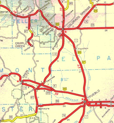
To illustrate the magnitude all of these little highways weaving all over the place, I present a scan of the Pueblo-Colorado Springs corridor, taking from the 1947 map. Take note of all of the highways running all over the place. Now, look at the same area of the state from the 1955 map. See how things have changed? Most of those various links and spurs have been turned back, and it looks remarkably like the highway system of today.
It was a nightmare trying to catalog of these short, little highways, then putting them up on this site. Basically, I started on it in March 1998 but didn't finish until November. Fortunately, I finished and you can now take a look at all of these highways that existed for less than 20 years by looking for the yellow color in the route tables.
These 1940s route numbers were assigned via clustering. Here's where these various clusters occurred (routes omitted are out of place or I have not found them):
|
Route Range |
Where Routes Were |
|---|---|
|
1-19 |
Not 1940s routes; used in original 1923 system (see above) |
|
20-40 |
North Front Range, North Eastern Plains |
|
41-49 |
Central Eastern Plains |
|
50-181 |
Not 1940s routes; used in original 1923 system (see above) |
|
182-189 |
Not 1940s routes; assigned in mid-1930s |
|
190-209 |
Southern Eastern Plains |
|
210-219 |
Denver-Colorado Springs corridor |
|
222, 224 |
North metro Denver |
|
225-236 |
South Front Range, east of Pueblo |
|
237-239, 241, 242, 244, 247-252 |
South Front Range, San Luis Valley |
|
240, 243, 245, 246, 253-265 |
North Front Range |
|
267-277 |
East Mountains, generally US 24 and US 50 corridors |
|
279-283, 285-290 |
East Mountains, north of US 6 |
|
291-302, 304, 306, 307, 310 |
Leadville/Dillon/Salida area |
|
303, 305 |
La Veta Pass area |
|
308, 311-318 |
West North Mountains |
|
320-326 |
Meeker area |
|
327-339, 341 |
Central Mountains |
|
340, 342-349 |
Grand Junction/Delta/Montrose area |
|
350, 352-361 |
Naturita/Ridgway/Silverton area |
|
362-378 |
South Mountains, San Luis Valley |
|
379-403 |
Not 1940s routes; assigned after 1945, metro Denver/North Front Range and metro Grand Junction |
During the last 30 years of the 20th Century, the Colorado highway system has seen none of the drastic changes that occurred in the 30 years before that. Looking outside of the Front Range, not much has happened. No major changes have occurred except for some rural highway mileage being turned back. Some gravel highways have been paved. There has been some expressway construction, and I-70 was finally completed through the mountains.
But, of course, things have been tumultuous along the Front Range. Beginning with Denver's boom in the 1970s, and then again with the whole Front Range growing in the 1990s, strain has been put on Colorado's highway system. CDH (which became CDOT in 1991) has been lagging until recently trying to keep up with everything. During the 1970s, the I-470 controversy in Denver resulted in SH 470, but probably left a bit of sour taste in CDH's mouth regarding the rest of the beltway. In the 1980s, the push to get more of Denver's beltway completed resulted in the Public Highway Authority Law, letting cities and counties form authorities to build toll roads. Toll roads have become all the rage over North America recently, as governments search for ways to meet transportation needs.
May 1923: The state Highway Advisory Board approves the highway system and route numbers that have descended to this day.1927: US Highway system implemented. In Colorado the new US routes were run over preexisting marked state highways.
1939: The state highway department takes on hundreds upon hundreds of miles of what were previously local roads, creating many of what I call 1940s routes.
1953: Many of the 1940s routes brought into the state system in 1939 are turned back.
1961: First state map to show Interstate Highways.
1967: Modern state route marker, with the state flag emblem, is adopted.
1968: CDH implements what I call the Purge of 1968, eliminating co-marking of state and US highways on maps and renumbering many state highways to avoid number duplication with US and Interstate highways.
June 1977: I-470 is officially withdrawn from the Interstate Highway system and its funding transferred to other projects.
August 1987: Public Highway Authority Law passed, allowing cities and counties to collaborate to form tollway authorities.
November 1999: The TRANs ballot measure passes, allowing CDOT to float bonds and speed up many construction projects. The vote is also de facto approval of I-25's Southeast Corridor project.
May 2002: Legislature passes law allowing CDOT to form a state toll authority and put tolls on new highway facilities.
2009: Colorado legislature passes the FASTER bill, raising vehicle registration fees to fund bridge replacement and safety projects. The bill is the first significant revenue added to the Colorado highway system in almost 20 years.
![]()
Continue:
Last updated 18 March 2011