|

|
- Welcome to Colorful Colorado. State welcome sign on I-25 entering from New Mexico at Raton Pass. August 2010
- Raton Pass Scenic Pullout. Northbound just north of the border is a scenic pullout, with this view looking to the north. August 2010
- Trinided
Business Loop. There is no state-maintained BL in
Trinidad. Perhaps it's a locally signed route, and CDOT played
along. Photo courtesy Mike Ballard.
- Overhead
Signs in Trinidad. Note the SH 12 sign has
a Scenic and Historic Byway marker on it. These signs no longer exist due to reconstrution. Photo courtesy Mike
Ballard.
- Commercial Street Exit.
Northound on the Trinidad viaduct, with barrier on the left side
because both directions of traffic were using the northbound side when
this picture was taken. August 2010
- Southbound Viaduct Reconstruction. The view from SH 12 under I-25 at the southbound viaduct under construction. August 2010
- I-25 & US 160 Overlap Markers. Proof the overlap of I-25 and US 160
is marked, here shown just north of Trinidad. August 2010
- Northbound Walsenburg Exit.
Northbound sign bridge at the exit for the Walsenburg business loop. US
160 doesn't technically leave I-25 until the next interchange, but
traffic is directed to get off here for Alamosa. August 2010
- Old Exit
49 Sign. 1990s sign that no longer exists. This has got to be one of the weirdest-looking guide
signs I've ever seen. All-caps, "NEXT RIGHT", black around the US
marker. Photo courtesy Mike Ballard.
- US 160/SH
10. Northbound I-25 as it's approaching the US 160/SH 10
interchange at Walsenburg, with a heck of a telephoto looking
ahead from the top of one crest to another. Photo by Mike
Ballard.
- Southbound Walsenburg Exit. Three sign panels piled onto an overhead sign bridge at Exit 52 on the north side of town. August 2010
- South of Exit 83. The scenery on southbound I-25 south of Exit 83 in Pueblo County. August 2010
- Stem Beach Interchange. The view from the top of the Stem Beach ramp looking north back toward Pueblo. May 2004
- Spanish Peaks. Southbound I-25 south of SH 45/Pueblo Blvd., looking all the way to the Spanish Peaks, 65 miles away. May 2004
- Pueblo Boulevard Interchange.
Northbound I-25 as one approaches the SH 45/Pueblo Blvd interchange on
the south side of Pueblo. In the distance you can see the stacks from
the Rocky Mountain Steel Mill. Photo by David Herrera. October 2005
- North of Indiana Avenue. Northbound I-25 at a railroad overpass north of Indiana Ave. in Pueblo. May 2004
- Approaching Abriendo. Northbound I-25 near Abriendo Avenue. Photo by
Mike Ballard.
- Arkansas Bridge. Northound I-25 going up and over the bridge over the Arkansas River in Pueblo. May 2004
- View from 8th Street. Looking south down on a curving, tree-lined I-25 from the 8th Street overpass in Pueblo. May 2004
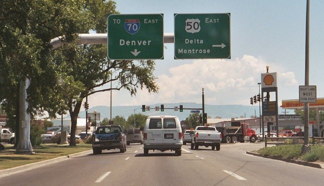
- US 50 East Interchange. Overhead signs on a very wide overhead sign structure at the US 50 East interchange in Pueblo. May 2004
- Southbound at 29th Street. Soutbound I-25 at 29th Street in Pueblo, featuring an unusual overhead sign with two arrows. May 2004
- US 50/SH 47 SPUI.
On the southbound offramp at Exit 101 in Pueblo, these are the overhead
signs as one approaches the SPUI intersection. May 2009
- Median Distance Sign. Nicely-done interchange sequence sign in the southbound median approaching Exit 101. May 2009
- Exit 101 3/4 Mile. Southbound sign announcing the US 50 West/SH 47 interchange. May 2009
- SH 16 Exit First Ramp and Second Ramp. Southbound at SH 16 (Exit 132) in Fountain, showing the signs for the two separate ramps. May 2009
- At Bijou Street.
Northbound I-25 at the Bijou Street underpass in Colorado
Springs. Photo by Russell Kroll. May 2003
- Near Uintah Street.
Shot looking north on I-25 from a pedestrain overpass
looking toward Uintah Street. September 2003
- Fillmore Street Double
Clearance. A shot of the underside of the Fillmore
Street underpass on northbound I-25 in Colorado Springs. It
appears that the Fillmore underpass was built as two
separate bridges (first the northside, then a while later
the south side), as evidenced by these two clearance signs.
Photo by Russell Kroll. May 2003
- Garden of the Gods
SPUI. A view of the SPUI at I-25 and Garden of the
Gods Road in Colorado Springs as seen sitting at the light
waiting to turn left from westbound GOTG to southbound I-25.
Photo courtesy David Herrera. August 2003
- Nevada/Corporate/Rockrimmon.
The southbound overhead sign at the Exit 140 split diamond
(post-COSMIX) which features three lines on it, not something you see
every day. February 2008
- Pikes Peak and Academy Boulevard.
A view of Colorado's most famous summit while on southbound I-25 in the
Academy Boulevard interchange (Exit 150). Photo by David Herrera. March
2004
- Monument Hill.
Looking south on I-25 from County Line Road at the summit of
Monument Hill. In the top right of the photo are two things
sticking up which are cell phone towers disguised as trees.
September 2003
- Rural Lighting North of Monument. Northbound I-25 just north of the
County Line Road interchange (Exit 163). This is in the rural
section that has lighting due to the possibility of severe winter
weather. Photo by Mike Ballard.
- Milepost 169.5. A
shot on northbound I-25 near Larkspur at milepost 169.5.
Photo courtesy David Herrera. July 2003
- Larkspur Exit & Butte.
Southbound I-25 at the Larkspur exit (Exit 173). In this stretch you're
pointed right at Larkspur Butte. Photo by David Herrera. October 2005
- Milepost 193: Median
Distance Sign. Shows how Colorado does distance
signing, and how it refers to the E-470 Tollway. Photo by
Mike Ballard.
- Exit 194: SH 470 and E-470
Sign. Another overhead sign approaching Exit 194.
Photo by Mike Ballard.
- Exit 194: Four-Level
Stack. Northbound approaching the Exit 194
interchange. The exit has already gone off to the right. Exit 194
is one of those fully directional, four-level "stack"
interchanges. The exit off in the distance is Exit 195, County
Line Road. Photo courtesy Mike Ballard.
- Arapahoe Station Pedestrian Bridge.
View of the pedestrian bridge across I-25 at the Arapahoe light rail
station, as seen from the Yosemite St overpass, looking north. September 2010
- The Tech Center Runway, 12 Lanes Wide.
I-25 in Greenwood Village as viewed looking north from the Orchard
station ped bridge in the Tech Center. In the distance is the Belleview
Ave exit. I call this section of I-25 "The Runway" because it's wide,
straight, fast and lit up like a Christmas tree at night. Septemer
2010
- I-25/225 From Union. A
look at the Full House undergoing T-REX construction facing
north from the Union Avenue overpass. March 2002
- I-25/225 From Quincy.
The Full House again, north facing south from the Quincy
Avenue overpass. March 2002
- T-REX Sign. One of
T-REX's large project signs, located on southbound I-25 at
I-225. March 2002
- Yale Avenue Bridge. A
shot of the bridge that takes I-25 over Yale Avenue in south
Denver. According to Michael McMullen, it was a high
performance concrete demonstration project, resulting in one
of the most slender prestressed concrete girder bridges in
the country. It has served as a prototype for a number of
the more slender bridges of this type in Colorado, allowing
longer spans or greater vertical clearance. The bridge was
built extra wide and as a result no widening or replacement
was required on it for the T-REX project. Photo by Greg
Gargan, via Michael McMullen.
- Evans Ramp Meter.
Northbound Evans Avenue on ramp in Denver, showing CDOT's
style of ramp meter. The sign says: Stop here on red / One
vehicle per green each lane. June 2000
- I-25 Northwest of University Boulevard, Looking Northbound and Looking Southbound.
These two pictures were taken from the top of the RTD University
Park-n-Ride garage. The northbound picture looks out over the light
rail station and into the mouth of the Narrows toward the Franklin
Street bridge. The southbound picture looks due east through the
University interchange. August 2006
- I-25 Narrows, Pre T-REX. This was how "The Narrows" section of I-25 looked in south
Denver before T-REX reconstruction, looking north from the Louisiana Ave. overpass. This was an
extremely substandard section of I-25, due to the fact no serious
upgrade had ever been made to the original Valley Highway through
here. January 1999
- Half Logan Bridge.
An interesting site for a couple weeks in Denver. As part of
T-REX the Logan Street overpass was being demolished, but
weather forced suspension while they were only halfway done.
This was the result. March 2003
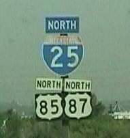
- I-25/US 85-87. A rare
US 87 sign northbound at the Santa Fe Drive onramp. This
sign no longer exists. Photo by Mike Ballard.
- Alameda Underpass. Northbound on I-25 going under Alameda Avenue. March 2007
- I-25/6th/8th Overhead
Signs. Three signs piled onto an overhead structure
northbound approaching 6th Avenue in Denver. Photo by Mike
Ballard.
- I-25 Near 8th Avenue, Invesco Field at Mile High.
Northbound I-25 in Denver between the 6th and Colfax Avenues exits. The
picture provides a pretty good overall view of I-25 in this area.
Directly ahead is Invesco Field at Mile High, visible through Xcel
Energy's Zuni generating station. Photo by David Herrera. October 2005
- Ramp Within Colfax
Interchange. On the ramp from westbound Colfax
Avenue to southbound I-25. The two-lane ramp on the left
side is from Auraria Parkway, while on the top of the
retaining wall to the right is the ramp from eastbound
Colfax. Photo by David Herrera. July 2003
- Platte River Bridge #1
and #2. Two
pictures of the bridge that takes I-25 over the South Platte
River north of Colfax Avenue. June 2001
- HOV Variable Message Sign. Northbound I-25 approaching the 20th Street exit
(212C) in Denver. Over on the right side of the gantry is the exit
sign for 20th St., while the thing on the left is the VMS for the upcoming
left exit to the HOV lanes. The VMS displays the status of the HOV lanes. May 1999
- Park Avenue West
Flyover. Looking north along Park Avenue at the
flyover taking SB I-25 and I-70 traffic onto southbound Park
into downtown. © CDOT from their Milestones
newsletter.
- I-25/38th Avenue Braid
Structure. In the maze of C-D roads along I-25 south
of I-70, this structure carries SB I-25 to Park Avenue over
SB I-25 to 38th Avenue. According to Michael McMullen, the
structure is only 21" thick (which is pretty thin) but is
able to span about 134' by using a trick related to the
severe skew and load paths. Photo courtesy Michael McMullen.
- HOV Lanes. If you
can make it out through the chain link fence, the two
separated HOV lanes are visible in the middle. Looking south
from the 44th Avenue overpass. January 1999
- Exit to I-70.
Northbound I-25 at the exit to the I-70 C-D road. Off to the
right is the ramp to Park Avenue West/38th Avenue peeling
off. Photo by David Herrera. July 2003
- Exit 216A: One of the
Worst Ramps in Denver. Southbound I-25 on the
collector/distributor ramp that goes to eastbound I-76. The
curve up ahead is signed for 20mph. May 1999
- Exit to US 36.
Northbound I-25 at the left exit for US 36 to Boulder. May
2001
- Ramp from I-76
Eastbound. Typical weekday congestion on the long
ramp from eastbound I-76 to northbound I-25. The ramp merges
with mainline I-25, which off to the left, just ahead. Photo
by David Herrera. July 2003
- Exit 240
Construction. Work that was going on to revamp the
I-25/SH 119 interchange, as seen on westbound SH 119. July
1998
- Little Thompson Valley.
Northbound approaching the Berthoud SH 56 exit is a long downhill grade
as I-25 falls into the valley for the Little Thompson River. I-25 is
visible climbing up the other side of the valley as is the odd kink to
the left I-25 has as it goes through the SH 56 interchange. October
2010
- Milepost 263.
Southbound near the Windsor exit, showing how busy I-25 is
on a typical weekday afternoon. June 1998
Additional I-25 Pictures: Steele
Street Bridge
|
|
|
|

Colorado
Springs
|
DEFUNCT HIGHWAY
- South End.
Southbound BL 25 on Nevada Avenue at I-25 Exit 140. Note
the vintage sign, that no longer exists. January 2001
- Close-Up.
Close-up of the vintage sign, courtesy Russell Kroll.
June 2001
- Nevada/Cimmaron.
Southbound BL 25 at Cimmaron Street. Oops! US 24 isn't
here anymore! Courtesy Russell Kroll. June 2001
- Parkway Median.
Extra-wide landscaped median for a parkway effect.
Northbound Nevada at Saint Vrain Street. September 2003
- Alternate Route
Lights. Covered lights and signs on a signal pole on
northbound Nevada at Austin Bluffs. Supposedly, if they were
uncovered, they would light up when the alternate route was
activated. Russell Kroll writes: "Here's an 'alternate
route' display. These have appeared all over town, but none
of them appear to be exposed. I assume this will be used to
route traffic up and down Nevada when something really bad
happens on I-25. TxDOT does something similar with signs
along Fredericksburg Rd. for I-10 here in San Antonio. I've
never seen them lit, but they supposedly can be used to keep
traffic away from the freeway in a pinch." Photo by Russell
Kroll. May 2003
|
|
|

|
- Leaving Colorful
Colorado. Westbound I-70 at the Utah border.
Depening on the situation you're either happy or sad seeing
this sign. Photo by Drew Willsey. July 2003
- Rabbit Valley.
Westbound on I-70 at the last exit before Utah. Doesn't
appear to be too much out here. Photo by Drew Willsey. July
2003
- Western Slope Vietnam Memorial.
On the property of the Fruita rest area is the Western Slope Vietnam
War Veterans Memorial, which features what looks like a real Huey
helicopter. July 2005
- Exit 26. Overhead signage on eastbound on I-70 at the west Grand Junction interchange. July 2005
- Near Grand
Junction. On westbound I-70 somewhere near Grand
Junction. Photo by Drew Willsey. July 2003
- Book Cliffs at Palisade.
Westbound I-70 at the west Palisade interchange, a view of the Book
Cliffs which I-70 is running along the south edge of above the Colorado
River. July 2005
- Beavertail Mountain Tunnel.
A blurry picture on westbound I-70 of the twin-bore Beavertail Mountain
Tunnel, northeast of the SH 65 interchange in De Beque Canyon. July
2005
- De Beque Canyon. Westbound on I-70 in De Beque Canyon at Milepost 54. July 2005
- Roan Plateau.
A view of the Roan Cliffs and Roan Plateau, on westbound I-70 near the
Mamm Creek/Garfield County Airport interchange. The plateau is home to
the boom and bust oil shale industry. July 2005
- How Far To the Middle of Utah?
This distance sign westbound after Dotsero is the first mention of
anything beyond Grand Junction. Since there's not too much to mention
between Grand Junction and where I-70 meets I-15 at Cove Fort, CDOT
punts and says simply "Jct I-15". May 2008
- West Vail Roundabout
Sign. The amazing array of choices the driver is
confronted with when exiting westbound I-70 to West Vail.
August 2003
- Vail Valley. Looking
west down I-70 in the Vail Valley from a pedestrian
overpass. August 2003
- Vail Pass Runaway
Ramp. A runaway ramp on westbound I-70 coming down
Vail Pass. June 2002
- Vail Pass Summit.
The view looking east from the rest area exit near the top
of Vail Pass. June 2002
- Tenmile Canyon, Copper
Mountain. Westbound I-70 in the canyon of Tenmile
Creek approaching the Copper Mountain (SH 91) exit. Photo by
Drew Willsey. July 2003
- Dillon Reservoir.
As seen from a scenic wayside on westbound I-70. June 2002
- Straight Creek
Canyon. Westbound I-70 as it plummets down Straight
Creek Canyon from the Eisenhower Tunnel toward Dillon. Photo
by Drew Willsey. July 2003
- Eisenhower Tunnel:
- East Portal
Signals. Westbound signals that are used to stop
traffic in case of a tunnel emergency, and a good view of
the portal itself. Photo by Drew Willsey. July 2003
- Mount Bethel.
Westbound west of Bakerville, one has a good view of 12,705' Mount
Bethel, which is off to the north side of I-70 at the unnamed Exit 218. May 2008
- VMS Warning. A sign
of the times during the Summer 2002 drought. On westbound
I-70 at Exit 232. June 2002
- Twin Tunnels. The
Twin Tunnels east of Idaho Springs, seen looking eastbound.
June 2002
- US 6 Clear Creek Canyon Left Exit.
Eastbound on I-70 at Exit 244, the US 6 Clear Creek Canyon exit east of
Idaho Springs. The left-most lane is the exit only lane to US 6. The
curve to the right I-70 has is only 50mph. March 2007
- Evergreen Parkway.
Westbound on I-70 at Evergeen Parkway (SH 74) at El Rancho.
Photo by Drew Willsey. July 2003
- Approaching Evergreen
Parkway. Westbound I-70 at Chief Hosa approaching
Evergreen Parkway. Photo by Drew Willsey. July 2003
- Genesee
Bridge Westbound (Nov. 2001) and Westbound (Mar. 2007). Looking west on I-70 from the Genesee
exit (Exit 254) west of Golden. Definitely one of the better
scenic vantage points in the state (and would've been even better
had there been no clouds shrouding the Divide). The view here is
made even grander by the design of the Genesee overpass. Coming
west on I-70, you pass under the bridge just as you're cresting a
hill, and the bridge is a single-span structure specifically made
to frame the mountain vistas beyond.
- Genesee
Bridge Plaque. A plaque in a parking area near the
Genesee bridge says it won "Most Beautiful Bridge" in 1971 from
AISC, the American Institute of Steel Construction. November
2001
- Eastbound.
The view eastbound along I-70 from the Genesee bridge, showing the
expanse of the Great Plains spread out before you. March 2007
- Exit 256. The
scenery looking east toward Denver from Exit 256. December
1997
- Golden Truck Runaway
Ramp. Eastbound at Milepost 257. July 1998
- Mount Vernon Canyon
Westbound. The view from westbound I-70 looking up
the steep grade up Mount Vernon Canyon west of Golden. Below
on the eastbound lanes you can see the runaway ramp in the
above picture. Photo by Drew Willsey. July 2003
- Morrison/Hogback.
Westbound I-70 as it approaches the huge cut through the
hogback before the Morrison/Hogback Road exit. Photo by Drew
Willsey. July 2003
- That's Not a Street Name, Mate, This Is a Street Name.
A picture of the signs on the signals if you exit I-70 at Exit 263.
Lakewood went more than just a little overboard with the street names
here, working names of businesses into the names of the streets. Try
saying "Denver West Colorado Mills Parkway" ten times fast. January
2009
- SH 58 Exit. Eastbound I-70 at the SH 58 Golden exit, showing the flyover swooping over to the left. January 2009
- Wadsworth/I-76 Complex.
Eastbound on I-70 approaching the Wadsworth Blvd/SH 121 interchange in
Arvada. Ahead the interchange complex for Wadsworth and I-76 looms. March 2007
- I-76 Left Exit. Overhead signs at the left exit for I-76 from I-70 in Arvada. March 2007
- Federal Boulevard.
Eastbound I-70 approaching US 287/Federal Blvd in Denver. This section
of I-70 has more of a "parkway" feel, with curves, greenery and wooden
sound walls. March 2007
- Elevated I-70.
Eastbound on I-70 on its elevated portion at York Street in
Denver. Note there are no shoulders and the destroyed impact
attenuator at the gore point. June 2003
- Elevated I-70,
Underneath. Looking at 46th Avenue under I-70 at
Elizabeth Street. November 2001
- I-70/I-270. Westbound
I-70 at the exit for I-270. February 2001
- Havana Street
Onramp. View of traffic queueing up at the meter
from Havana Street to westbound I-70 in Denver. Photo
courtesy David Herrera. July 2003
- I-70/I-225. Westbound
on a C-D road between Chambers Road and I-225. November 2001
- Airport Boulevard Overpass.
Westbound on I-70 at the Airport Boulevard overpass in Aurora. The
overpass features a wavy-top fence as an architectural enhancement. Off
to the right is the C-D road to the loop ramp to southbound Airport. May 2006
- I-70 at Colfax
Avenue. Eastbound overhead sign at Colfax Avenue in
east Aurora. This sign is unusual for Colorado in that it
has the exit advisory speed on it. February 2003
- I-70/E-470. Looking
east on I-70 at the E-470 interchange. May 1999
- East Bijou Creek Bridge.
Westbound on I-70 at the East Bijou Creek bridge northwest of Deer
Trail. The creek is lined with trees, so I-70 passes through a
cozy-looking grove of trees as it crosses the creek. Interesting clouds
in the sky, too. May 2006
- SH 86 Rolling Prairie. The view looking northwest along I-70 across the high plains from the SH 86 overpass, near Limon. May 2004
- Westbound at Burlington
Business Loop. Westbound at the first exit after the
Kansas border, Exit 438 to Burlington. Photo by Dale
Sanderson. December 2003
Additional I-70 Pictures: Glenwood
Canyon
|
|
|

Grand
Junction
|
- US 50 Intersection.
Overhead signs on eastbound BL 70/US 50 at the Pitkin/5th intersection
downtown. The intersection features a double right turn. July 2005
-
BL 70/6/141 Markers. Eastbound BL 70/US 6 at the SH 141 intersection near Clifton. Oops! Those arrows are in the wrong place. July 2005
|
|
|
|

Eagle
|
- Roundabout. On
southbound BS 70 approaching the roundabout at US 6 in
Eagle. June 2002
- Eagle Roundabout. A picture looking west on US 6 at the BL 70 roundabout on the east side of Eagle. Photo by Phil Demosthenes.
|
|
|
|
Avon
|
DEFUNCT HIGHWAY
- Tear Drop
Roundabout. On the south side of the I-70
interchange at Avon. Photo courtesy Phil Demosthenes.
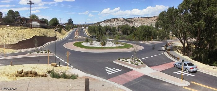
- I-70/Avon Road Roundabouts Overview.
A shot looking southeast from above Avon providing a good overview of
the Avon Road roundabouts. As Avon Road goes toward the upper right you
can see it has additional roundabouts as it goes through Avon. Photo by
Phil Demosthenes. July 2004
|
|
|
|
Burlington
|
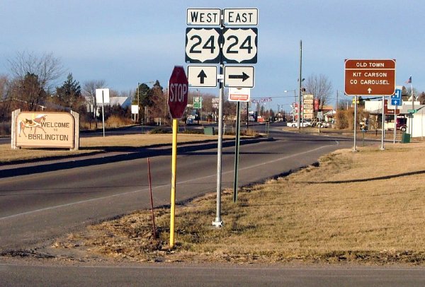
- US 24, East
Burlington. Westbound on BL 70 in Burlington at
its intersection with US 24 on the east side of town. Photo
by Dale Sanderson. December 2003
|
|
|
|

|
- I-76/US 85. Eastbound
I-76 at the left exit for US 85 in Commerce City. June 2001
- Milepost 54. Eastbound I-76 as crosses the plains at Milepost 54, between Roggen and Wiggins. May 2007
- SH 39/52 Exit. Eastbound on I-76 at the SH 39/52 exit at Wiggins. May 2007
- Fort Morgan Business Loop.
Eastbound on I-76 at Exit 75, the US 34/BL 76 exit to Fort Morgan. The
sign features the "EAST" on a separate plate, as if it were slapped on
as an afterthought. May 2007
- Dodd Bridge Road. Westbound on I-76 near Dodd Bridge Road, Exit 86 near Brush. May 2005
- Spur 34 Exit.
Eastbound I-76 approaching Exit 92 near Brush, the US 6/Spur 34 exit.
Usually you don't see three towns listed on the same exit sign. May 2007
|
|
|
|

|
- Tunnel to Southbound I-25.
Traffic on I-225 going to southbound I-25 uses a tunnel to cross under
all the other levels within the interchange. October 2007
- South End. Southbound
I-225 at I-25. February 2001
- North of Colfax. A
view of the wide expanse of concrete that is southbound
I-225 north of Colfax. August 2003
- North End. Northbound
at I-70. February 2001
|
|
|
|

|
- I-270 East, I-25
North. Eastbound right at the point over I-25
where US 36 becomes I-270 and the ramp to northbound I-25
peels off to the right. On the left side is a "Being Future
270 East" sign still partially covered. August 2003
- End 270/Begin 36.
Blurry picture of the signs on westbound I-270 at I-25.
February 2001
- East of I-25. Eastbound
I-270 east of I-25 on brand new concrete the same day it
opened to traffic. Mop up work is still going on in the
right lane. Lots of unused concrete is off to the left side
for when the ramp from southbund I-25 will tie in to I-270
creating more lanes. August 2003
- Temporary Signs. A
blurry picture showing temporary signs on westbound I-270
approaching I-76. October 1999
- Vasquez Overhead
Signs. Eastbound I-270 at the overhead signs for the
Vasquez Boulevard cloverleaf. Note US 85 and SH 2 are shown,
but US 6 is missing. Photo courtesy David Herrera. July 2003
|