Colorado Highways:
Elevation-Related Trivia Items


Municipality Elevation Ranks

Highest Municipalities:
1. Alma - 10,355 ft*
2. Montezuma - 10,335 ft*
3. Leadville - 10,152 ft*
4. Blue River - 10,020 ft*
5. Fairplay - 9953 ft
6. Victor - 9693 ft
7. Breckenridge - 9603 ft
8. Cripple Creek - 9494 ft
9. Mountain Village - 9400 ft
9. Bonanza - 9400 ft


Lowest Municipalities:
261. Wiley - 3731 ft
262. Crook - 3711 ft
263. Lamar - 3622 ft
264. Hartman - 3600 ft
265. Ovid - 3521 ft
266. Wray - 3516 ft
267. Sedgwick - 3500 ft
268. Granada - 3484 ft
269. Julesburg - 3477 ft
270. Holly - 3397 ft


* Elevation is "official" USGS elevation, verified by me looking at USGS contour maps. In some cases these are different from the elevations listed on the CDOT state map. Elevations without * are what is listed on the CDOT state map.

Discussion on highest: You'll notice that Leadville is not the highest. Since it's lower than Alma by a full 200 feet I'm going to call bogus its claim to being the highest incorporated city in the continental U.S. However, if you get nitpicky you could make a case that Leadville is indeed the highest city, because Alma and Montezuma are officially towns, not cities. But that to me is not good enough, Alma and Montezuma are incorporated municipalities just like Leadville. Another possibility for the confusion might be that at one time Leadville actually was the highest municipality and Alma and Montezuma incorporated after Leadville started making its claim. Speculation on my part.

Discussion on lowest: No surprise. Holly is in the Arkansas River valley, near what is the third-lowest point in Colorado (more on Colorado low points from Dale Sanderson). Julesburg is in the South Platte River valley. In fact, 9 of the towns in the "bottom 10" are in either the Arkansas or South Platte valleys.


Highest/Lowest Points on State Highways

Highest Points:
1. SH 5, Mount Evans - 14,160 ft
2. US 34, Trail Ridge Road - 12,183 ft
3. SH 82, Independence Pass - 12,095 ft
4. US 6, Loveland Pass - 11,992 ft
5. SH 9, Hoosier Pass - 11,541 ft
6. SH 149, Slumgullion Pass - 11,361 ft
7. SH 91, Fremont Pass - 11,318 ft
8. US 40, Berthoud Pass - 11,315 ft
9. US 50, Monarch Pass - 11,312 ft
10. I-70, Eisenhower Tunnel West Portal - 11,158 ft


Lowest Points:
• US 34 at the Nebraska border, North Fork Republican River - 3355 ft
• US 50 at the Kansas border, Arkansas River - 3375 ft

Discussion on highest: Elevations are as listed on the CDOT state map, except Mount Evans, where they listed the elevation of the mountain rather than the highway. The highway stops about 100' below the summit.

Discussion on lowest: No surprise that it's on Colorado's eastern border. However, it is interesting that it's not US 50 beside the Arkansas. US 50 is apparently a good distance above the Arkansas, just enough for US 34 to slip in under it. The next lowest highways are the ones around Julesburg, but those are about 100' higher than US 34. Elevations were determined looking at USGS topographical maps. Elevations are estimated to the nearest 5' because contour intervals in those locations are 10'.


Denver's Official Mile-High Marker

Denver, since its downtown area is at about 5280' above sea level, is known as the Mile High City. The Colorado State Capitol, on its west steps, has a survey marker marking the exact point of elevation 5280'. But elevations change over time, based on redefinition of where sea level is and better surveying technology. Because of this, there are actually three separate 5280' markers on the Capitol steps. The original, one from 1969, and one from 2003. Pictures taken February 2004.


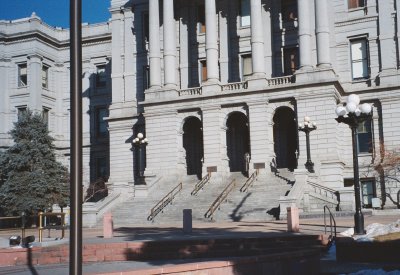
An overall view of the state Capitol's west steps.

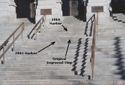
Closer in to the steps, showing the relative positions of the three markers.


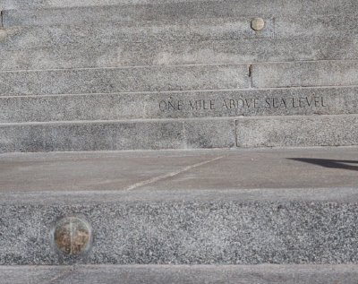
A close-up of the three separate markers. The bottom one is the 2003 metal disc. In the middle is the original engraved step. And on top is the 1969 metal disc.

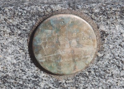
A close-in look at the 1969 marker. It's very plain, just a round metal disc with the inscription "Elevation 5280.000 / One Mile High / 5-12-69". I assume the dot toward the top is the actual point of 5280'.


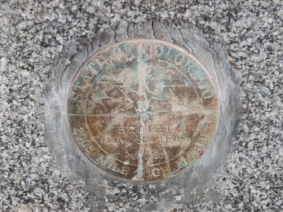
A close-in look at the 2003 marker. This one is fairly ornate, with an engraved mountain motif. Its inscription reads "State of Colorado / 2003 Mile High Marker / 5280 Feet Above Sea Level / NAVD 88". That last part refers to North American Vertical Datum 1988. I assume the horizontal line through the middle of the marker is the actual point of 5280'.

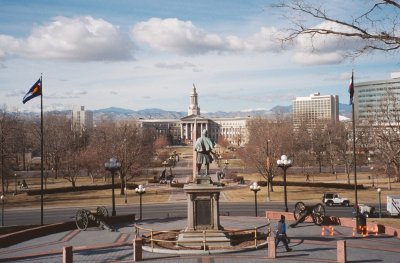
The view looking west from the markers, out over the Civil War Memorial, Civic Center Park and the Denver City and County Building.


Continue:

Page created 6 August 2003
Last updated 24 November 2006