Glenwood Canyon: An I-70
Odyssey
Guide to I-70 in the Canyon
![]()
![]()
![]()
![]()
![]()
The following is a guide to I-70 as it now is in Glenwood Canyon, going from west to east. Several photos appear, but there are many more photos in the Photo Album, accessible through the link at the left.
General
I-70 in Glenwood Canyon hugs the north side of Colorado River, except where is crosses over to the south side of the river for the Hanging Lake Tunnel. Generally the lower eastbound lanes are right adjacent to the river supported by retaining walls, while the higher westbound lanes alternate between being supported by retaining walls and being on viaducts.
In order to build I-70, a special Federal Highway Administration waiver was required to have a lower speed limit, 50 mph. With the lower speed limit it was possible to build sharper curves on the highway so that the freeway could more easily be aligned to snake through the canyon. It is the lowest permanent speed limit on an Interstate in Colorado.
 Four
rest areas were built in the canyon: No Name, Grizzly Creek,
Hanging Lake, and Bair Ranch. There is also a concrete
recreation trail which goes the entire length of the canyon
along the north bank, from Glenwood Springs to west of
Dotsero. The rest areas serves the rec trail in addition to
the highway. Recreation uses in the canyon include hiking,
biking, fishing, rafting, picnicking and wildlife viewing.
Four
rest areas were built in the canyon: No Name, Grizzly Creek,
Hanging Lake, and Bair Ranch. There is also a concrete
recreation trail which goes the entire length of the canyon
along the north bank, from Glenwood Springs to west of
Dotsero. The rest areas serves the rec trail in addition to
the highway. Recreation uses in the canyon include hiking,
biking, fishing, rafting, picnicking and wildlife viewing.
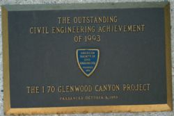
The plaque at left, from the Grizzly Creek rest area, advertises one of Glenwood Canyon's many awards: Outstanding Civil Engineering Achievement of 1993, from the American Society of Civil Engineers. ASCE gives out one OCEA award every year.
Glenwood Springs & No Name
After passing through Glenwood Springs at Milepost 116, I-70 immediately enters Glenwood Canyon. The rec trail starts off on the north side of the highway, and together they go toward the No Name Tunnels, twin bores just west of the No Name interchange. The No Name Tunnels allow I-70 to bypass a section of the canyon known as Horseshoe Curve, which is a very sharp oxbow which "points" to the south. At the west portal of the tunnels the rec trail goes up and over a pedestrian overpass, and follows the Colorado River through Horseshoe Curve and uses a section of US 6-24 which was abandoned as a road when the tunnels were built in 1965.
The No Name Tunnels (Milepost 117) are simple two-lane bores. The photo at right is taken from the pedestrian overpass looking at the west portal of the tunnels. The blur in the lower part of the picture is a chain link fence I was shooting through.
After emerging from the east portal of the tunnels, I-70 goes to a wide area in the canyon. The wide area includes the No Name diamond interchange on I-70 (Exit 119), a rest area, and an enclave of a bunch of houses and businesses. From Horseshoe Curve, the rec trail uses a local county road up a steep hill to No Name. At the rest area the rec trail goes back to its own dedicated concrete path beside the river.
East of No Name, the canyon necks back down being narrow. There are no major bridges or viaducts until Grizzly Creek. At Grizzly Creek, there is an interchange and rest area (Exit 121). Grizzly Creek is a stream that gurgles south into Glenwood Canyon, and I-70 has twin viaducts to carry it over the creek and the lower road of the interchange. The interchange is a full interchange, with ramps supporting all movements. East of Grizzly Creek, I-70 continues to snake its way through the canyon, then flies onto twin viaducts as it approaches the Shoshone Power Plant.
Shoshone Power Plant to Hanging Lake
The Shoshone Power Plant, located at Milepost 123 on I-70, is a hydroelectric plant on the north bank of the Colorado River. However, rather the traditional plant that has a dam at the same location, Shoshone is different. The Shoshone Dam is located two miles upstream at Milepost 125. The dam creates a still lake on the Colorado River, and water from the lake flows through an artificial diversion tunnel in the north wall of the canyon to the power plant, where the diversion tunnel exits the canyon wall and drops through the power plant to generate power. Since the water is diverted out of the Colorado at the dam, if flow in the river is low enough the unusual phenomenon can result where the entire river is flowing through the diversion tunnel and the river is dry for the two miles between the dam and power plant. This was the case when I visited in June 2002.
I-70 flies onto twin viaducts and goes directly over the Shoshone Power Plant. The plant has an interchange on I-70 (Exit 123), but is only a partial interchange. Ramps exist for getting from eastbound I-70 to the plant and from the plant to westbound I-70 only. The road that the ramps feed onto underneath I-70 includes parking for a raft launch that is on the north bank of the river just downstream of the outlet of the power plant. Since there is a dam two miles upstream and the Colorado River can be dry upstream of the power plant, this is the furthest east a raft launch can be and rafters still be able to float all the way to Glenwood Springs.
The picture at right is looking east underneath the twin I-70 viaducts as they fly over the Shoshone Power Plant. The people at the railing on the right at looking down at the river at the raft launch area.
East of the Shoshone Power Plant the river goes up an incline, and the highway comes off its twin viaducts with both roadways being supported by retaining walls. During low flow times, the river can be dry as the entire flow of the Colorado is diverted through the Shoshone diversion tunnel. As the freeway is less than a mile from the west portal of the Hanging Lake Tunnel, the freeway again flies onto twin viaducts.
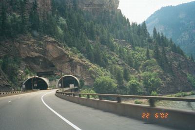
Hanging Lake Tunnel
America's smartest highway tunnel. That's what the Hanging Lake Tunnel has been called, due to the extensive use of technology in it. The Hanging Lake Tunnel is actually two separate two-lane bores in the south wall of the canyon. As I-70 approaches the tunnel on both sides, viaducts take I-70 from the north bank over the Colorado River and directly into the tunnel portals. The tunnel allows I-70 to be completely removed from the canyon in the Hanging Lake area.
The Hanging Lake bores are 3900' long. There is a 4-floor control center partially embedded in the south canyon slope about halfway between the two portals. 20 cameras allow CDOT employees to view the entire tunnel and react to emergencies. Approaching the tunnel from either direction are overhead variable message signs (VMSs), which allow motorists to be advised of situations. There are also variable speed limit signs approaching the tunnel, so the limits can be lowered from the default 50 mph if required. Green arrow/red X lane use signals advise if lanes are open or closed.
 Perhaps
one of the most innovative uses of technology with the
tunnel is the AM-FM rebroadcast system. Radio signals
outside the tunnel are received and then rebroadcast inside
the tunnel with an antenna system, allowing motorists to go
through the tunnel without having the Elton John song
playing be interrupted. CDOT workers can commandeer the
rebroadcast system in an emergency, overriding the normal
AM-FM signals with their own announcements. According to the
July 11, 2002 Rocky Mountains News, one motorist even
had an announcement about a lane closure override a cassette
tape that they had playing while they went through the
tunnel. CDOT was quite surprised to find out it even
overrode cassettes. In my personal experience over two days,
the rebroadcast system seemed to work pretty well.
Perhaps
one of the most innovative uses of technology with the
tunnel is the AM-FM rebroadcast system. Radio signals
outside the tunnel are received and then rebroadcast inside
the tunnel with an antenna system, allowing motorists to go
through the tunnel without having the Elton John song
playing be interrupted. CDOT workers can commandeer the
rebroadcast system in an emergency, overriding the normal
AM-FM signals with their own announcements. According to the
July 11, 2002 Rocky Mountains News, one motorist even
had an announcement about a lane closure override a cassette
tape that they had playing while they went through the
tunnel. CDOT was quite surprised to find out it even
overrode cassettes. In my personal experience over two days,
the rebroadcast system seemed to work pretty well.
The picture at right is on westbound I-70, at the point it flies from the north bank of the Colorado to the south, and enters the Hanging Lake Tunnel. Note the overhead VMS for messages just before the portal.
"Lake Shoshone" and Hanging Lake Trailhead
There are several features along the Colorado River and I-70 at the point where I-70 disappears into the Hanging Lake Tunnel. Just west of the west portal of the tunnel is the Hanging Lake interchange (Exit 125). The interchange serves the Shoshone Dam and the Hanging Lake rest area/trailhead. The interchange, like Shoshone, is only a partial interchange, with ramps from eastbound I-70 to the rest area and from the rest area to westbound I-70. Drivers coming westbound on I-70 that want to get to Hanging Lake have to go further west to the Grizzly Creek interchange and pull a U-turn.
From the interchange, the ramps go down underneath I-70 and feed onto what was once US 6 along the north bank of the Colorado. The road goes over a short bridge which takes it over the Shoshone Dam, where water is diverted into the diversion tunnel and to the power plant. The road goes a short distance and ends at a parking area at the rest area. The rest area also serves as the trailhead for the Hanging Lake Trail. The trail goes up Dead Horse Creek to Hanging Lake and Bridal Veil Falls.
The Shoshone Dam creates a lake behind it which I call "Lake Shoshone" for lack of anything better. With the freeway removed from the canyon by means of the tunnel, the "Lake Shoshone" area is a very quiet, idyllic place. The only noise and activity comes from people on the rec trail and the Hanging Lake Trail. Water in the river does not make much noise since it is moving very slowly through the lake.
East of Hanging Lake & Reverse Curve Tunnel
From the east portal of the Hanging Lake Tunnel, I-70 flies from the south bank of the Colorado back to the north bank. It remains on twin viaducts for awhile, until finally the eastbound road touches down again. The westbound road remains on a high viaduct that takes it all the way to the Reverse Curve Tunnel. The Reverse Curve Tunnel (Milepost 127) is a short, single bore tunnel through a rock outcropping for only the westbound lanes. The eastbound road runs alongside the outcropping. On either side of it the westbound road is on high viaducts, and as it approaches the Reverse Curve Tunnel the road suddenly dives down to be closer to the eastbound road. It is called "reverse curve" due to a double curve in the river at that point (similar to the shape of a "chicane" on a race course).
French Creek Viaduct
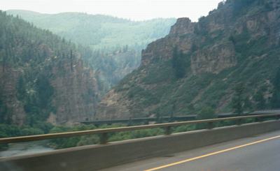 East
of the Reverse Curve is the French Creek Viaduct (Milepost
128), which takes westbound I-70 over the area where French
Creek flows south into the Colorado River. The westbound
viaduct is 4000 feet long, and holds westbound I-70 from the
Reverse Curve Tunnel all the way to near the Bair Ranch
interchange. The westbound viaduct is up very high, making
for a good view from it. The eastbound road has a much
shorter viaduct, just in the area where it goes it over
French Creek.
East
of the Reverse Curve is the French Creek Viaduct (Milepost
128), which takes westbound I-70 over the area where French
Creek flows south into the Colorado River. The westbound
viaduct is 4000 feet long, and holds westbound I-70 from the
Reverse Curve Tunnel all the way to near the Bair Ranch
interchange. The westbound viaduct is up very high, making
for a good view from it. The eastbound road has a much
shorter viaduct, just in the area where it goes it over
French Creek.
The photo at right is westbound atop the French Creek Viaduct, looking southwest down the canyon.
Bair Ranch to Dotsero
East of the French Creek Viaduct both directions touch down again for the last time, for there are no major viaduct structures east of French Creek. I-70 approaches the Bair Ranch interchange (Exit 128), a full interchange which serves a rest area. Vehicles longer than 35 feet cannot use the rest area, due to the tightness of how the rest area is laid out. The Bair Ranch rest area is named for the Bair Family, early prominent sheep ranchers in the area.
At Bair Ranch, Glenwood Canyon loses its narrowness and starts to open up. I-70 is a lot less curvy and there are no major bridge or viaduct structures. I-70 crosses the Garfield/Eagle County line at Milepost 129, and east of that the canyon pretty much disappears and becomes a broad valley. The speed changes from 50 mph back to the standard 75 mph, and I-70 goes through the Dotsero interchange (Exit 133).